Tłuszcz geodata
Tłuszcz (Mazovia) is a seat of a third-order administrative division; located in Poland in Europe/Warsaw (GMT+2) time zone. With population of 7,482 people, there are 520 cities with bigger population in this country. Compared to other cities in Poland, 75.3% of cities are located further ↓South; 78.4% of cities are located further ←West and 79.3% of cities have higher elevation than Tłuszcz. Note1


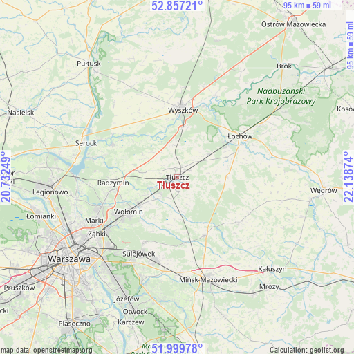
Tłuszcz GPS coordinates[2]
52° 25' 50.088" North, 21° 26' 8.196" East
| Map corner | latitude | longitude |
|---|---|---|
| Upper-left | 52.85721°, | 20.73249° |
| Center: | 52.43058°, | 21.43561° |
| Lower-right: | 51.99978°, | 22.13874° |
| Map W x H: | 95.3×95.3 km | = 59.2×59.2mi |
| max Lat: | 54.83135° ⇑24.7% North |
| Tłuszcz: | 52.43058° |
| min Lat: | ⇓75.3% South 49.21328° |
| min Long | Tłuszcz | max Long |
| 14.20249° | 21.43561° | 24.03723° |
| W 78.4%⇐ | ⇒21.6% E |
Elevation
Elevation of Tłuszcz is 101 m = 331 ft, and this is 90.4 m = 297 ft below average elevation for this country.
| Max E: |
974 m = 3196 ft | 79.3% |
| Avg. | 191.4 m = 628 ft | |
| Tłuszcz | 101 m = 331 ft | |
Min E: |
-3 m = -10 ft | 20.7% |
See also: Poland elevation on elevation.city.
Geographical zone
Tłuszcz is located in North temperate zone (between Tropic of Cancer and the Arctic Circle). Distance of this North polar circle is 1571.4 km =976.4 mi to North.| Distance of | km | miles | from Tłuszcz |
|---|---|---|---|
| North Pole | 4177.3 | 2595.7 | to North |
| Arctic Circle | 1571.4 | 976.4 | to North |
| Tropic Cancer | 3223.8 | 2003.2 | to South |
| Equator | 5829.7 | 3622.4 | to South |


Nearby cities:
15 places around Tłuszcz: (largest is in red/bold)
• Czarna
15.8 km =9.8 mi,  244°
244°
• Duczki
12.4 km =7.7 mi,  232°
232°
• Dąbrówka
11.1 km =6.9 mi,  302°
302°
• Jadów
14.3 km =8.9 mi,  68°
68°
• Jasienica
2.5 km =1.6 mi,  221°
221°
• Klembów
7.5 km =4.7 mi,  249°
249°
• Nowe Lipiny
13.8 km =8.6 mi, 234°
• Ostrówek
6.5 km =4 mi, 225°
• Poświętne
11.3 km =7 mi,  184°
184°
• Radzymin
17.1 km =10.6 mi,  264°
264°
• Rybno
15.5 km =9.6 mi,  353°
353°
• Stare Grabie
10.4 km =6.5 mi, 229°
• Strachówka
13.5 km =8.4 mi,  91°
91°
• Wołomin
16.5 km =10.3 mi, 232°
• Zabrodzie
8.9 km =5.5 mi, 352°
Sources, notices
• [Note1] Compared only with cities in Poland existing in our database
• [Src1] Map data: © OpenStreetMap contributors (CC-BY-SA)
• [Src2] Other city data from geonames.org with taken over terms of usage.
• [Src3] Geographical zone / Annual Mean Temperature by Robert A. Rohde @ Wikipedia
