Jedlińsk geodata
Jedlińsk (Mazovia) is a seat of a third-order administrative division; located in Poland in Europe/Warsaw (GMT+2) time zone. With population of 1,700 people, there are 1678 cities with bigger population in this country. Compared to other cities in Poland, 56.6% of cities are located further ↓South; 74.6% of cities are located further ←West and 67.4% of cities have higher elevation than Jedlińsk. Note1


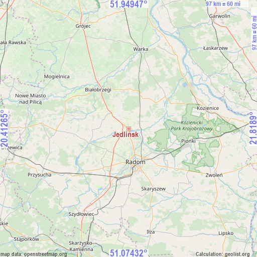
Jedlińsk GPS coordinates[2]
51° 30' 50.4" North, 21° 6' 56.772" East
| Map corner | latitude | longitude |
|---|---|---|
| Upper-left | 51.94947°, | 20.41265° |
| Center: | 51.514°, | 21.11577° |
| Lower-right: | 51.07432°, | 21.8189° |
| Map W x H: | 97.3×97.3 km | = 60.5×60.5mi |
| max Lat: | 54.83135° ⇑43.4% North |
| Jedlińsk: | 51.514° |
| min Lat: | ⇓56.6% South 49.21328° |
| min Long | Jedlińsk | max Long |
| 14.20249° | 21.11577° | 24.03723° |
| W 74.6%⇐ | ⇒25.4% E |
Elevation
Elevation of Jedlińsk is 127 m = 417 ft, and this is 64.4 m = 211 ft below average elevation for this country.
| Max E: |
974 m = 3196 ft | 67.4% |
| Avg. | 191.4 m = 628 ft | |
| Jedlińsk | 127 m = 417 ft | |
Min E: |
-3 m = -10 ft | 32.6% |
See also: Poland elevation on elevation.city.
Geographical zone
Jedlińsk is located in North temperate zone (between Tropic of Cancer and the Arctic Circle). Distance of this North polar circle is 1673.4 km =1039.8 mi to North.| Distance of | km | miles | from Jedlińsk |
|---|---|---|---|
| North Pole | 4279.2 | 2659 | to North |
| Arctic Circle | 1673.4 | 1039.8 | to North |
| Tropic Cancer | 3121.9 | 1939.9 | to South |
| Equator | 5727.8 | 3559.1 | to South |


Nearby cities:
15 places around Jedlińsk: (largest is in red/bold)
• Głowaczów
18.5 km =11.5 mi,  49°
49°
• Jastrzębia
8.6 km =5.3 mi,  102°
102°
• Jedlnia-Letnisko
17.8 km =11.1 mi,  121°
121°
• Ludwinów
18.5 km =11.5 mi,  184°
184°
• Podlesie Duże
13 km =8.1 mi,  11°
11°
• Przytyk
15.5 km =9.6 mi,  249°
249°
• Radom
12.6 km =7.8 mi,  170°
170°
• Radzanów
18.1 km =11.2 mi,  285°
285°
• Stara Błotnica
10.4 km =6.5 mi, 290°
• Stromiec
14.9 km =9.3 mi,  353°
353°
• Sucha
16.5 km =10.3 mi,  315°
315°
• Sławno
15.8 km =9.8 mi,  207°
207°
• Trablice
18 km =11.2 mi, 177°
• Wolanów
17.7 km =11 mi, 212°
• Zakrzew
11.4 km =7.1 mi,  224°
224°
Sources, notices
• [Note1] Compared only with cities in Poland existing in our database
• [Src1] Map data: © OpenStreetMap contributors (CC-BY-SA)
• [Src2] Other city data from geonames.org with taken over terms of usage.
• [Src3] Geographical zone / Annual Mean Temperature by Robert A. Rohde @ Wikipedia
