Radzanów geodata
Radzanów (Mazovia) is a seat of a third-order administrative division; located in Poland in Europe/Warsaw (GMT+2) time zone. With population of 356 people, there are 3607 cities with bigger population in this country. Compared to other cities in Poland, 57.2% of cities are located further ↓South; 70.3% of cities are located further ←West and 55.3% of cities have higher elevation than Radzanów. Note1


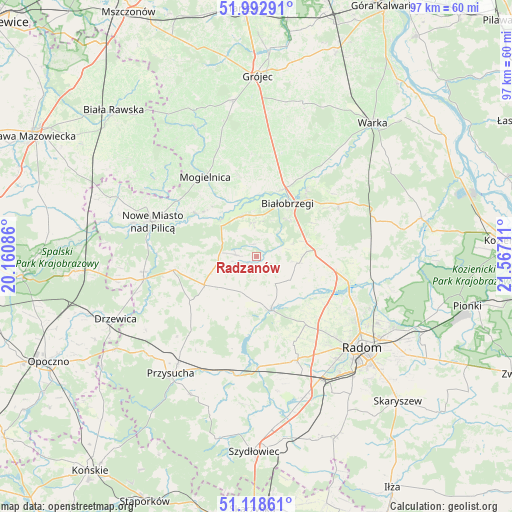
Radzanów GPS coordinates[2]
51° 33' 28.296" North, 20° 51' 50.328" East
| Map corner | latitude | longitude |
|---|---|---|
| Upper-left | 51.99291°, | 20.16086° |
| Center: | 51.55786°, | 20.86398° |
| Lower-right: | 51.11861°, | 21.56711° |
| Map W x H: | 97.2×97.2 km | = 60.4×60.4mi |
| max Lat: | 54.83135° ⇑42.8% North |
| Radzanów: | 51.55786° |
| min Lat: | ⇓57.2% South 49.21328° |
| min Long | Radzanów | max Long |
| 14.20249° | 20.86398° | 24.03723° |
| W 70.3%⇐ | ⇒29.7% E |
Elevation
Elevation of Radzanów is 158 m = 518 ft, and this is 33.4 m = 110 ft below average elevation for this country.
| Max E: |
974 m = 3196 ft | 55.3% |
| Avg. | 191.4 m = 628 ft | |
| Radzanów | 158 m = 518 ft | |
Min E: |
-3 m = -10 ft | 44.7% |
See also: Poland elevation on elevation.city.
Geographical zone
Radzanów is located in North temperate zone (between Tropic of Cancer and the Arctic Circle). Distance of this North polar circle is 1668.5 km =1036.8 mi to North.| Distance of | km | miles | from Radzanów |
|---|---|---|---|
| North Pole | 4274.4 | 2656 | to North |
| Arctic Circle | 1668.5 | 1036.8 | to North |
| Tropic Cancer | 3126.8 | 1942.9 | to South |
| Equator | 5732.7 | 3562.1 | to South |


Nearby cities:
15 places around Radzanów: (largest is in red/bold)
• Białobrzegi
11.6 km =7.2 mi,  31°
31°
• Goszczyn
19.4 km =12.1 mi,  357°
357°
• Jedlińsk
18.1 km =11.2 mi,  105°
105°
• Klwów
15.9 km =9.9 mi,  260°
260°
• Mogielnica
18.1 km =11.2 mi,  327°
327°
• Nowe Miasto nad Pilicą
21 km =13 mi,  288°
288°
• Potworów
11.3 km =7 mi,  240°
240°
• Promna
15.1 km =9.4 mi, 25°
• Przybyszew
11.8 km =7.3 mi, 355°
• Przytyk
10.7 km =6.6 mi,  164°
164°
• Stara Błotnica
7.8 km =4.8 mi,  99°
99°
• Stromiec
18.6 km =11.6 mi,  57°
57°
• Sucha
9.1 km =5.7 mi,  40°
40°
• Wyśmierzyce
8.2 km =5.1 mi,  335°
335°
• Zakrzew
16.1 km =10 mi,  143°
143°
Sources, notices
• [Note1] Compared only with cities in Poland existing in our database
• [Src1] Map data: © OpenStreetMap contributors (CC-BY-SA)
• [Src2] Other city data from geonames.org with taken over terms of usage.
• [Src3] Geographical zone / Annual Mean Temperature by Robert A. Rohde @ Wikipedia
