Radom geodata
Radom (Mazovia) is a seat of a second-order administrative division; located in Poland in Europe/Warsaw (GMT+2) time zone. With population of 226,794 people, there are 14 cities with bigger population in this country. Compared to other cities in Poland, 54.9% of cities are located further ↓South; 75.1% of cities are located further ←West and 54.9% of cities have higher elevation than Radom. Note1


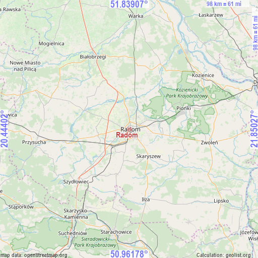
Radom GPS coordinates[2]
51° 24' 9.108" North, 21° 8' 49.704" East
| Map corner | latitude | longitude |
|---|---|---|
| Upper-left | 51.83907°, | 20.44402° |
| Center: | 51.40253°, | 21.14714° |
| Lower-right: | 50.96178°, | 21.85027° |
| Map W x H: | 97.5×97.5 km | = 60.6×60.6mi |
| max Lat: | 54.83135° ⇑45.1% North |
| Radom: | 51.40253° |
| min Lat: | ⇓54.9% South 49.21328° |
| min Long | Radom | max Long |
| 14.20249° | 21.14714° | 24.03723° |
| W 75.1%⇐ | ⇒24.9% E |
Elevation
Elevation of Radom is 159 m = 522 ft, and this is 32.4 m = 106 ft below average elevation for this country.
| Max E: |
974 m = 3196 ft | 54.9% |
| Avg. | 191.4 m = 628 ft | |
| Radom | 159 m = 522 ft | |
Min E: |
-3 m = -10 ft | 45.1% |
See also: Radom elevation on elevation.city.
Geographical zone
Radom is located in North temperate zone (between Tropic of Cancer and the Arctic Circle). Distance of this North polar circle is 1685.7 km =1047.4 mi to North.| Distance of | km | miles | from Radom |
|---|---|---|---|
| North Pole | 4291.6 | 2666.7 | to North |
| Arctic Circle | 1685.7 | 1047.4 | to North |
| Tropic Cancer | 3109.5 | 1932.2 | to South |
| Equator | 5715.4 | 3551.4 | to South |


Nearby cities:
15 places around Radom: (largest is in red/bold)
• Gózd
16.3 km =10.1 mi,  99°
99°
• Jastrzębia
12.3 km =7.6 mi,  30°
30°
• Jedlińsk
12.6 km =7.8 mi,  350°
350°
• Jedlnia-Letnisko
13.4 km =8.3 mi,  76°
76°
• Kowala
10.2 km =6.3 mi,  211°
211°
• Ludwinów
7 km =4.3 mi, 210°
• Maków
9.7 km =6 mi,  130°
130°
• Mazowszany
7.1 km =4.4 mi,  186°
186°
• Orońsko
14.7 km =9.1 mi,  227°
227°
• Rzeczków
16.2 km =10.1 mi,  201°
201°
• Skaryszew
12.5 km =7.8 mi,  144°
144°
• Sławno
9.5 km =5.9 mi,  259°
259°
• Trablice
5.7 km =3.5 mi, 192°
• Wolanów
12.1 km =7.5 mi, 258°
• Zakrzew
11 km =6.8 mi,  292°
292°
Sources, notices
• [Note1] Compared only with cities in Poland existing in our database
• [Src1] Map data: © OpenStreetMap contributors (CC-BY-SA)
• [Src2] Other city data from geonames.org with taken over terms of usage.
• [Src3] Geographical zone / Annual Mean Temperature by Robert A. Rohde @ Wikipedia
