Stara Błotnica geodata
Stara Błotnica (Mazovia) is a seat of a third-order administrative division; located in Poland in Europe/Warsaw (GMT+2) time zone. With population of 272 people, there are 3631 cities with bigger population in this country. Compared to other cities in Poland, 57.1% of cities are located further ↓South; 72.2% of cities are located further ←West and 57.6% of cities have higher elevation than Stara Błotnica. Note1


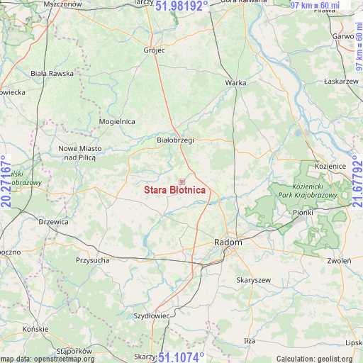
Stara Błotnica GPS coordinates[2]
51° 32' 48.336" North, 20° 58' 29.244" East
| Map corner | latitude | longitude |
|---|---|---|
| Upper-left | 51.98192°, | 20.27167° |
| Center: | 51.54676°, | 20.97479° |
| Lower-right: | 51.1074°, | 21.67792° |
| Map W x H: | 97.2×97.2 km | = 60.4×60.4mi |
| max Lat: | 54.83135° ⇑42.9% North |
| Stara Błotnica: | 51.54676° |
| min Lat: | ⇓57.1% South 49.21328° |
| min Long | Stara Błotnica | max Long |
| 14.20249° | 20.97479° | 24.03723° |
| W 72.2%⇐ | ⇒27.8% E |
Elevation
Elevation of Stara Błotnica is 152 m = 499 ft, and this is 39.4 m = 129 ft below average elevation for this country.
| Max E: |
974 m = 3196 ft | 57.6% |
| Avg. | 191.4 m = 628 ft | |
| Stara Błotnica | 152 m = 499 ft | |
Min E: |
-3 m = -10 ft | 42.4% |
See also: Poland elevation on elevation.city.
Geographical zone
Stara Błotnica is located in North temperate zone (between Tropic of Cancer and the Arctic Circle). Distance of this North polar circle is 1669.7 km =1037.5 mi to North.| Distance of | km | miles | from Stara Błotnica |
|---|---|---|---|
| North Pole | 4275.6 | 2656.7 | to North |
| Arctic Circle | 1669.7 | 1037.5 | to North |
| Tropic Cancer | 3125.5 | 1942.1 | to South |
| Equator | 5731.5 | 3561.4 | to South |


Nearby cities:
15 places around Stara Błotnica: (largest is in red/bold)
• Białobrzegi
11.3 km =7 mi,  351°
351°
• Jastrzębia
19 km =11.8 mi,  106°
106°
• Jedlińsk
10.4 km =6.5 mi, 110°
• Podlesie Duże
15.4 km =9.6 mi,  53°
53°
• Potworów
18 km =11.2 mi,  256°
256°
• Promna
14.9 km =9.3 mi,  355°
355°
• Przybyszew
15.5 km =9.6 mi,  326°
326°
• Przytyk
10.2 km =6.3 mi,  207°
207°
• Radzanów
7.8 km =4.8 mi,  279°
279°
• Stromiec
13.8 km =8.6 mi,  36°
36°
• Sucha
8.3 km =5.2 mi, 347°
• Sławno
17.9 km =11.1 mi,  171°
171°
• Wolanów
18.5 km =11.5 mi,  179°
179°
• Wyśmierzyce
14.1 km =8.8 mi,  308°
308°
• Zakrzew
11.9 km =7.4 mi, 171°
Sources, notices
• [Note1] Compared only with cities in Poland existing in our database
• [Src1] Map data: © OpenStreetMap contributors (CC-BY-SA)
• [Src2] Other city data from geonames.org with taken over terms of usage.
• [Src3] Geographical zone / Annual Mean Temperature by Robert A. Rohde @ Wikipedia
