Podlesie Duże geodata
Podlesie Duże (Mazovia) is a populated place; located in Poland in Europe/Warsaw (GMT+2) time zone. With population of 711 people, there are 3048 cities with bigger population in this country. Compared to other cities in Poland, 58.6% of cities are located further ↓South; 75.2% of cities are located further ←West and 62.7% of cities have higher elevation than Podlesie Duże. Note1


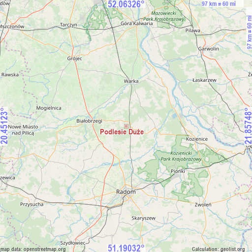
Podlesie Duże GPS coordinates[2]
51° 37' 44.004" North, 21° 9' 15.66" East
| Map corner | latitude | longitude |
|---|---|---|
| Upper-left | 52.06326°, | 20.45123° |
| Center: | 51.62889°, | 21.15435° |
| Lower-right: | 51.19032°, | 21.85748° |
| Map W x H: | 97.1×97.1 km | = 60.3×60.3mi |
| max Lat: | 54.83135° ⇑41.4% North |
| Podlesie Duże: | 51.62889° |
| min Lat: | ⇓58.6% South 49.21328° |
| min Long | Podlesie Duże | max Long |
| 14.20249° | 21.15435° | 24.03723° |
| W 75.2%⇐ | ⇒24.8% E |
Elevation
Elevation of Podlesie Duże is 140 m = 459 ft, and this is 51.4 m = 169 ft below average elevation for this country.
| Max E: |
974 m = 3196 ft | 62.7% |
| Avg. | 191.4 m = 628 ft | |
| Podlesie Duże | 140 m = 459 ft | |
Min E: |
-3 m = -10 ft | 37.3% |
See also: Poland elevation on elevation.city.
Geographical zone
Podlesie Duże is located in North temperate zone (between Tropic of Cancer and the Arctic Circle). Distance of this North polar circle is 1660.6 km =1031.8 mi to North.| Distance of | km | miles | from Podlesie Duże |
|---|---|---|---|
| North Pole | 4266.5 | 2651.1 | to North |
| Arctic Circle | 1660.6 | 1031.8 | to North |
| Tropic Cancer | 3134.7 | 1947.8 | to South |
| Equator | 5740.6 | 3567 | to South |


Nearby cities:
15 places around Podlesie Duże: (largest is in red/bold)
• Białobrzegi
14.2 km =8.8 mi,  278°
278°
• Głowaczów
11.3 km =7 mi,  93°
93°
• Jastrzębia
15.7 km =9.8 mi,  158°
158°
• Jedlińsk
13 km =8.1 mi,  191°
191°
• Magnuszew
21.7 km =13.5 mi,  45°
45°
• Promna
14.6 km =9.1 mi,  292°
292°
• Przybyszew
21.2 km =13.2 mi, 280°
• Radzanów
21.6 km =13.4 mi,  248°
248°
• Ryczywół
19.7 km =12.2 mi,  69°
69°
• Stara Błotnica
15.4 km =9.6 mi,  233°
233°
• Stromiec
4.7 km =2.9 mi,  295°
295°
• Sucha
14.2 km =8.8 mi,  266°
266°
• Warka
17.5 km =10.9 mi,  8°
8°
• Wyśmierzyce
23.5 km =14.6 mi, 268°
• Zakrzew
23.4 km =14.5 mi,  206°
206°
Sources, notices
• [Note1] Compared only with cities in Poland existing in our database
• [Src1] Map data: © OpenStreetMap contributors (CC-BY-SA)
• [Src2] Other city data from geonames.org with taken over terms of usage.
• [Src3] Geographical zone / Annual Mean Temperature by Robert A. Rohde @ Wikipedia
