Zakrzew geodata
Zakrzew (Mazovia) is a seat of a third-order administrative division; located in Poland in Europe/Warsaw (GMT+2) time zone. With population of 339 people, there are 3612 cities with bigger population in this country. Compared to other cities in Poland, 55.4% of cities are located further ↓South; 72.7% of cities are located further ←West and 54.2% of cities have higher elevation than Zakrzew. Note1


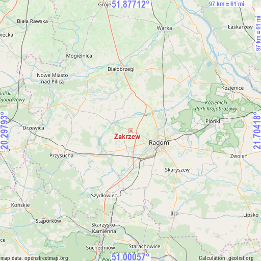
Zakrzew GPS coordinates[2]
51° 26' 27.42" North, 21° 0' 3.78" East
| Map corner | latitude | longitude |
|---|---|---|
| Upper-left | 51.87712°, | 20.29793° |
| Center: | 51.44095°, | 21.00105° |
| Lower-right: | 51.00057°, | 21.70418° |
| Map W x H: | 97.5×97.5 km | = 60.6×60.6mi |
| max Lat: | 54.83135° ⇑44.6% North |
| Zakrzew: | 51.44095° |
| min Lat: | ⇓55.4% South 49.21328° |
| min Long | Zakrzew | max Long |
| 14.20249° | 21.00105° | 24.03723° |
| W 72.7%⇐ | ⇒27.3% E |
Elevation
Elevation of Zakrzew is 161 m = 528 ft, and this is 30.4 m = 100 ft below average elevation for this country.
| Max E: |
974 m = 3196 ft | 54.2% |
| Avg. | 191.4 m = 628 ft | |
| Zakrzew | 161 m = 528 ft | |
Min E: |
-3 m = -10 ft | 45.8% |
See also: Poland elevation on elevation.city.
Geographical zone
Zakrzew is located in North temperate zone (between Tropic of Cancer and the Arctic Circle). Distance of this North polar circle is 1681.5 km =1044.8 mi to North.| Distance of | km | miles | from Zakrzew |
|---|---|---|---|
| North Pole | 4287.4 | 2664.1 | to North |
| Arctic Circle | 1681.5 | 1044.8 | to North |
| Tropic Cancer | 3113.8 | 1934.8 | to South |
| Equator | 5719.7 | 3554.1 | to South |


Nearby cities:
15 places around Zakrzew: (largest is in red/bold)
• Jastrzębia
17.5 km =10.9 mi,  68°
68°
• Jedlińsk
11.4 km =7.1 mi,  44°
44°
• Kowala
13.7 km =8.5 mi,  159°
159°
• Ludwinów
12.2 km =7.6 mi,  147°
147°
• Mazowszany
14.7 km =9.1 mi,  140°
140°
• Orońsko
14.2 km =8.8 mi,  182°
182°
• Przytyk
7.1 km =4.4 mi,  292°
292°
• Radom
11 km =6.8 mi,  112°
112°
• Radzanów
16.1 km =10 mi,  323°
323°
• Rzeczków
19.8 km =12.3 mi,  168°
168°
• Stara Błotnica
11.9 km =7.4 mi,  351°
351°
• Sławno
6 km =3.7 mi, 172°
• Trablice
13.2 km =8.2 mi, 137°
• Wieniawa
16.8 km =10.4 mi,  238°
238°
• Wolanów
6.9 km =4.3 mi,  193°
193°
Sources, notices
• [Note1] Compared only with cities in Poland existing in our database
• [Src1] Map data: © OpenStreetMap contributors (CC-BY-SA)
• [Src2] Other city data from geonames.org with taken over terms of usage.
• [Src3] Geographical zone / Annual Mean Temperature by Robert A. Rohde @ Wikipedia
