Jedlnia-Letnisko geodata
Jedlnia-Letnisko (Mazovia) is a seat of a third-order administrative division; located in Poland in Europe/Warsaw (GMT+2) time zone. With population of 3,692 people, there are 879 cities with bigger population in this country. Compared to other cities in Poland, 55.3% of cities are located further ↓South; 77.3% of cities are located further ←West and 55.6% of cities have higher elevation than Jedlnia-Letnisko. Note1


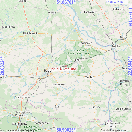
Jedlnia-Letnisko GPS coordinates[2]
51° 25' 50.664" North, 21° 20' 7.296" East
| Map corner | latitude | longitude |
|---|---|---|
| Upper-left | 51.86701°, | 20.63224° |
| Center: | 51.43074°, | 21.33536° |
| Lower-right: | 50.99026°, | 22.03849° |
| Map W x H: | 97.5×97.5 km | = 60.6×60.6mi |
| max Lat: | 54.83135° ⇑44.7% North |
| Jedlnia-Letnisko: | 51.43074° |
| min Lat: | ⇓55.3% South 49.21328° |
| min Long | Jedlnia-Letnisk | max Long |
| 14.20249° | 21.33536° | 24.03723° |
| W 77.3%⇐ | ⇒22.7% E |
Elevation
Elevation of Jedlnia-Letnisko is 157 m = 515 ft, and this is 34.4 m = 113 ft below average elevation for this country.
| Max E: |
974 m = 3196 ft | 55.6% |
| Avg. | 191.4 m = 628 ft | |
| Jedlnia-Letnisko | 157 m = 515 ft | |
Min E: |
-3 m = -10 ft | 44.4% |
See also: Poland elevation on elevation.city.
Geographical zone
Jedlnia-Letnisko is located in North temperate zone (between Tropic of Cancer and the Arctic Circle). Distance of this North polar circle is 1682.6 km =1045.5 mi to North.| Distance of | km | miles | from Jedlnia-Letnisko |
|---|---|---|---|
| North Pole | 4288.5 | 2664.7 | to North |
| Arctic Circle | 1682.6 | 1045.5 | to North |
| Tropic Cancer | 3112.6 | 1934.1 | to South |
| Equator | 5718.6 | 3553.4 | to South |


Nearby cities:
15 places around Jedlnia-Letnisko: (largest is in red/bold)
• Garbatka-Letnisko
20 km =12.4 mi,  73°
73°
• Gózd
6.6 km =4.1 mi,  152°
152°
• Jastrzębia
10.1 km =6.3 mi,  317°
317°
• Jedlińsk
17.8 km =11.1 mi,  301°
301°
• Kazanów
19.5 km =12.1 mi, 151°
• Ludwinów
19 km =11.8 mi,  241°
241°
• Maków
11.1 km =6.9 mi,  211°
211°
• Mazowszany
17.2 km =10.7 mi,  233°
233°
• Pionki
9.4 km =5.8 mi,  57°
57°
• Policzna
20.4 km =12.7 mi,  82°
82°
• Radom
13.4 km =8.3 mi,  256°
256°
• Skaryszew
14.5 km =9 mi,  203°
203°
• Tczów
14 km =8.7 mi, 146°
• Trablice
16.8 km =10.4 mi, 238°
• Zwoleń
19.4 km =12.1 mi,  115°
115°
Sources, notices
• [Note1] Compared only with cities in Poland existing in our database
• [Src1] Map data: © OpenStreetMap contributors (CC-BY-SA)
• [Src2] Other city data from geonames.org with taken over terms of usage.
• [Src3] Geographical zone / Annual Mean Temperature by Robert A. Rohde @ Wikipedia
