Strzelce Wielkie geodata
Strzelce Wielkie (Lesser Poland) is a populated place; located in Poland in Europe/Warsaw (GMT+2) time zone. With population of 835 people, there are 2790 cities with bigger population in this country. Compared to other cities in Poland, 78.3% of cities are located further ↑North; 66.1% of cities are located further ←West and 53.5% of cities have lower elevation than Strzelce Wielkie. Note1


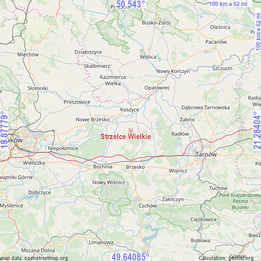
Strzelce Wielkie GPS coordinates[2]
50° 5' 38.58" North, 20° 34' 51.276" East
| Map corner | latitude | longitude |
|---|---|---|
| Upper-left | 50.543°, | 19.87779° |
| Center: | 50.09405°, | 20.58091° |
| Lower-right: | 49.64085°, | 21.28404° |
| Map W x H: | 100.3×100.3 km | = 62.3×62.3mi |
| max Lat: | 54.83135° ⇑78.3% North |
| Strzelce Wielkie: | 50.09405° |
| min Lat: | ⇓21.7% South 49.21328° |
| min Long | Strzelce Wielki | max Long |
| 14.20249° | 20.58091° | 24.03723° |
| W 66.1%⇐ | ⇒33.9% E |
Elevation
Elevation of Strzelce Wielkie is 181 m = 594 ft, and this is 10.4 m = 34 ft below average elevation for this country.
| Max E: |
974 m = 3196 ft | 46.5% |
| Avg. | 191.4 m = 628 ft | |
| Strzelce Wielkie | 181 m = 594 ft | |
Min E: |
-3 m = -10 ft | 53.5% |
See also: Poland elevation on elevation.city.
Geographical zone
Strzelce Wielkie is located in North temperate zone (between Tropic of Cancer and the Arctic Circle). Distance of this North polar circle is 1831.2 km =1137.9 mi to North.| Distance of | km | miles | from Strzelce Wielkie |
|---|---|---|---|
| North Pole | 4437.1 | 2757.1 | to North |
| Arctic Circle | 1831.2 | 1137.9 | to North |
| Tropic Cancer | 2964 | 1841.7 | to South |
| Equator | 5569.9 | 3461 | to South |


Nearby cities:
15 places around Strzelce Wielkie: (largest is in red/bold)
• Baczków
12 km =7.5 mi,  236°
236°
• Borek
9.2 km =5.7 mi,  202°
202°
• Borzęcin
9.8 km =6.1 mi,  108°
108°
• Drwinia
9.9 km =6.2 mi,  272°
272°
• Dziewin
9.2 km =5.7 mi,  257°
257°
• Grobla
11.6 km =7.2 mi,  287°
287°
• Jodłówka
11.5 km =7.1 mi,  191°
191°
• Koszyce
8.5 km =5.3 mi,  359°
359°
• Przyborów
9.2 km =5.7 mi,  140°
140°
• Rudy-Rysie
5.5 km =3.4 mi,  131°
131°
• Rzezawa
12.5 km =7.8 mi, 202°
• Szczepanów
11.2 km =7 mi,  152°
152°
• Szczurowa
4.8 km =3 mi,  54°
54°
• Uście Solne
5.5 km =3.4 mi,  300°
300°
• Zaborów
9.8 km =6.1 mi, 53°
Sources, notices
• [Note1] Compared only with cities in Poland existing in our database
• [Src1] Map data: © OpenStreetMap contributors (CC-BY-SA)
• [Src2] Other city data from geonames.org with taken over terms of usage.
• [Src3] Geographical zone / Annual Mean Temperature by Robert A. Rohde @ Wikipedia
