Grabowiec geodata
Grabowiec (Lublin) is a seat of a third-order administrative division; located in Poland in Europe/Warsaw (GMT+2) time zone. With population of 922 people, there are 2631 cities with bigger population in this country. Compared to other cities in Poland, 59.7% of cities are located further ↑North; 99% of cities are located further ←West and 65.3% of cities have lower elevation than Grabowiec. Note1


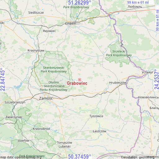
Grabowiec GPS coordinates[2]
50° 49' 15.24" North, 23° 33' 2.052" East
| Map corner | latitude | longitude |
|---|---|---|
| Upper-left | 51.26299°, | 22.84745° |
| Center: | 50.8209°, | 23.55057° |
| Lower-right: | 50.37459°, | 24.2537° |
| Map W x H: | 98.8×98.8 km | = 61.4×61.4mi |
| max Lat: | 54.83135° ⇑59.7% North |
| Grabowiec: | 50.8209° |
| min Lat: | ⇓40.3% South 49.21328° |
| min Long | Grabowiec | max Long |
| 14.20249° | 23.55057° | 24.03723° |
| W 99%⇐ | ⇒1% E |
Elevation
Elevation of Grabowiec is 215 m = 705 ft, and this is 23.6 m = 77 ft above average elevation for this country.
| Max E: |
974 m = 3196 ft | 34.7% |
| Grabowiec | 215 m 705 ft | |
| Avg. | 191.4 m = 628 ft | |
Min E: |
-3 m = -10 ft | 65.3% |
See also: Poland elevation on elevation.city.
Geographical zone
Grabowiec is located in North temperate zone (between Tropic of Cancer and the Arctic Circle). Distance of this North polar circle is 1750.4 km =1087.6 mi to North.| Distance of | km | miles | from Grabowiec |
|---|---|---|---|
| North Pole | 4356.3 | 2706.9 | to North |
| Arctic Circle | 1750.4 | 1087.6 | to North |
| Tropic Cancer | 3044.8 | 1892 | to South |
| Equator | 5650.8 | 3511.2 | to South |


Nearby cities:
15 places around Grabowiec: (largest is in red/bold)
• Białopole
22.3 km =13.9 mi,  34°
34°
• Dębowiec
15.5 km =9.6 mi,  260°
260°
• Jarosławiec
14.3 km =8.9 mi,  47°
47°
• Komarów-Osada
22 km =13.7 mi,  193°
193°
• Kraśniczyn
18.7 km =11.6 mi,  311°
311°
• Miączyn
9.8 km =6.1 mi,  200°
200°
• Sitno
15.4 km =9.6 mi,  238°
238°
• Skierbieszów
13.9 km =8.6 mi,  284°
284°
• Trzeszczany
13.1 km =8.1 mi,  89°
89°
• Uchanie
12.1 km =7.5 mi,  35°
35°
• Werbkowice
16.8 km =10.4 mi,  116°
116°
• Wojsławice
10.9 km =6.8 mi,  358°
358°
• Zamość
23.6 km =14.7 mi, 242°
• Łabunie
22.5 km =14 mi,  215°
215°
• Żmudź
23.6 km =14.7 mi,  21°
21°
Sources, notices
• [Note1] Compared only with cities in Poland existing in our database
• [Src1] Map data: © OpenStreetMap contributors (CC-BY-SA)
• [Src2] Other city data from geonames.org with taken over terms of usage.
• [Src3] Geographical zone / Annual Mean Temperature by Robert A. Rohde @ Wikipedia
