Werbkowice geodata
Werbkowice (Lublin) is a populated place; located in Poland in Europe/Warsaw (GMT+2) time zone. With population of 3,030 people, there are 1034 cities with bigger population in this country. Compared to other cities in Poland, 61.3% of cities are located further ↑North; 99.7% of cities are located further ←West and 57.7% of cities have lower elevation than Werbkowice. Note1


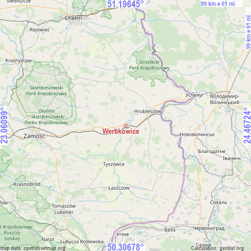
Werbkowice GPS coordinates[2]
50° 45' 13.428" North, 23° 45' 50.796" East
| Map corner | latitude | longitude |
|---|---|---|
| Upper-left | 51.19645°, | 23.06099° |
| Center: | 50.75373°, | 23.76411° |
| Lower-right: | 50.30678°, | 24.46724° |
| Map W x H: | 98.9×98.9 km | = 61.5×61.5mi |
| max Lat: | 54.83135° ⇑61.3% North |
| Werbkowice: | 50.75373° |
| min Lat: | ⇓38.7% South 49.21328° |
| min Long | Werbkowice | max Long |
| 14.20249° | 23.76411° | 24.03723° |
| W 99.7%⇐ | ⇒0.3% E |
Elevation
Elevation of Werbkowice is 193 m = 633 ft, and this is 1.6 m = 5 ft above average elevation for this country.
| Max E: |
974 m = 3196 ft | 42.3% |
| Werbkowice | 193 m 633 ft | |
| Avg. | 191.4 m = 628 ft | |
Min E: |
-3 m = -10 ft | 57.7% |
See also: Poland elevation on elevation.city.
Geographical zone
Werbkowice is located in North temperate zone (between Tropic of Cancer and the Arctic Circle). Distance of this North polar circle is 1757.9 km =1092.3 mi to North.| Distance of | km | miles | from Werbkowice |
|---|---|---|---|
| North Pole | 4363.8 | 2711.5 | to North |
| Arctic Circle | 1757.9 | 1092.3 | to North |
| Tropic Cancer | 3037.4 | 1887.4 | to South |
| Equator | 5643.3 | 3506.6 | to South |


Nearby cities:
15 places around Werbkowice: (largest is in red/bold)
• Grabowiec
16.8 km =10.4 mi,  296°
296°
• Horodło
24.8 km =15.4 mi,  50°
50°
• Hrebenne
22 km =13.7 mi, 52°
• Hrubieszów
10.7 km =6.6 mi,  57°
57°
• Jarosławiec
17.7 km =11 mi,  345°
345°
• Komarów-Osada
24.5 km =15.2 mi,  235°
235°
• Michałów
25.6 km =15.9 mi,  206°
206°
• Mircze
14.7 km =9.1 mi,  140°
140°
• Miączyn
18.6 km =11.6 mi,  264°
264°
• Telatyn
25.8 km =16 mi,  168°
168°
• Trzeszczany
7.7 km =4.8 mi, 345°
• Tyszowce
15.9 km =9.9 mi,  196°
196°
• Uchanie
19 km =11.8 mi,  335°
335°
• Wojsławice
23.9 km =14.9 mi,  320°
320°
• Łaszczów
24.7 km =15.3 mi,  186°
186°
Sources, notices
• [Note1] Compared only with cities in Poland existing in our database
• [Src1] Map data: © OpenStreetMap contributors (CC-BY-SA)
• [Src2] Other city data from geonames.org with taken over terms of usage.
• [Src3] Geographical zone / Annual Mean Temperature by Robert A. Rohde @ Wikipedia
