Wojsławice geodata
Wojsławice (Lublin) is a populated place; located in Poland in Europe/Warsaw (GMT+2) time zone. With population of 1,600 people, there are 1751 cities with bigger population in this country. Compared to other cities in Poland, 57.2% of cities are located further ↑North; 98.9% of cities are located further ←West and 66.4% of cities have lower elevation than Wojsławice. Note1


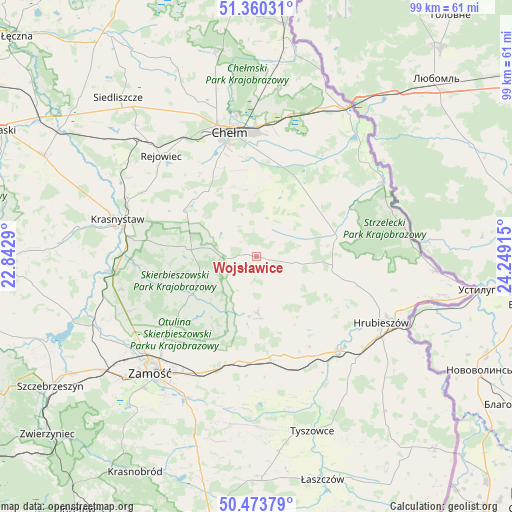
Wojsławice GPS coordinates[2]
50° 55' 8.976" North, 23° 32' 45.672" East
| Map corner | latitude | longitude |
|---|---|---|
| Upper-left | 51.36031°, | 22.8429° |
| Center: | 50.91916°, | 23.54602° |
| Lower-right: | 50.47379°, | 24.24915° |
| Map W x H: | 98.6×98.6 km | = 61.3×61.3mi |
| max Lat: | 54.83135° ⇑57.2% North |
| Wojsławice: | 50.91916° |
| min Lat: | ⇓42.8% South 49.21328° |
| min Long | Wojsławice | max Long |
| 14.20249° | 23.54602° | 24.03723° |
| W 98.9%⇐ | ⇒1.1% E |
Elevation
Elevation of Wojsławice is 218 m = 715 ft, and this is 26.6 m = 87 ft above average elevation for this country.
| Max E: |
974 m = 3196 ft | 33.6% |
| Wojsławice | 218 m 715 ft | |
| Avg. | 191.4 m = 628 ft | |
Min E: |
-3 m = -10 ft | 66.4% |
See also: Poland elevation on elevation.city.
Geographical zone
Wojsławice is located in North temperate zone (between Tropic of Cancer and the Arctic Circle). Distance of this North polar circle is 1739.5 km =1080.9 mi to North.| Distance of | km | miles | from Wojsławice |
|---|---|---|---|
| North Pole | 4345.4 | 2700.1 | to North |
| Arctic Circle | 1739.5 | 1080.9 | to North |
| Tropic Cancer | 3055.8 | 1898.8 | to South |
| Equator | 5661.7 | 3518 | to South |


Nearby cities:
15 places around Wojsławice: (largest is in red/bold)
• Białopole
15 km =9.3 mi,  60°
60°
• Dębowiec
20.1 km =12.5 mi,  228°
228°
• Grabowiec
10.9 km =6.8 mi,  178°
178°
• Jarosławiec
10.9 km =6.8 mi,  96°
96°
• Kamień
19.9 km =12.4 mi,  7°
7°
• Kraśniczyn
13.9 km =8.6 mi,  275°
275°
• Miączyn
20.4 km =12.7 mi,  188°
188°
• Pokrówka
20.4 km =12.7 mi,  343°
343°
• Siennica Różana
18.1 km =11.2 mi,  300°
300°
• Sitno
22.8 km =14.2 mi,  214°
214°
• Skierbieszów
15.1 km =9.4 mi,  240°
240°
• Trzeszczany
17.3 km =10.7 mi,  129°
129°
• Uchanie
7.5 km =4.7 mi, 98°
• Werbkowice
23.9 km =14.9 mi,  140°
140°
• Żmudź
14.3 km =8.9 mi,  39°
39°
Sources, notices
• [Note1] Compared only with cities in Poland existing in our database
• [Src1] Map data: © OpenStreetMap contributors (CC-BY-SA)
• [Src2] Other city data from geonames.org with taken over terms of usage.
• [Src3] Geographical zone / Annual Mean Temperature by Robert A. Rohde @ Wikipedia
