Jarosławiec geodata
Jarosławiec (Lublin) is a populated place; located in Poland in Europe/Warsaw (GMT+2) time zone. With population of 520 people, there are 3482 cities with bigger population in this country. Compared to other cities in Poland, 57.5% of cities are located further ↑North; 99.5% of cities are located further ←West and 67.7% of cities have lower elevation than Jarosławiec. Note1


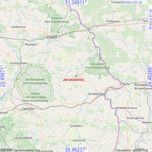
Jarosławiec GPS coordinates[2]
50° 54' 28.26" North, 23° 41' 59.388" East
| Map corner | latitude | longitude |
|---|---|---|
| Upper-left | 51.34911°, | 22.99671° |
| Center: | 50.90785°, | 23.69983° |
| Lower-right: | 50.46237°, | 24.40296° |
| Map W x H: | 98.6×98.6 km | = 61.3×61.3mi |
| max Lat: | 54.83135° ⇑57.5% North |
| Jarosławiec: | 50.90785° |
| min Lat: | ⇓42.5% South 49.21328° |
| min Long | Jarosławiec | max Long |
| 14.20249° | 23.69983° | 24.03723° |
| W 99.5%⇐ | ⇒0.5% E |
Elevation
Elevation of Jarosławiec is 222 m = 728 ft, and this is 30.6 m = 100 ft above average elevation for this country.
| Max E: |
974 m = 3196 ft | 32.3% |
| Jarosławiec | 222 m 728 ft | |
| Avg. | 191.4 m = 628 ft | |
Min E: |
-3 m = -10 ft | 67.7% |
See also: Poland elevation on elevation.city.
Geographical zone
Jarosławiec is located in North temperate zone (between Tropic of Cancer and the Arctic Circle). Distance of this North polar circle is 1740.8 km =1081.7 mi to North.| Distance of | km | miles | from Jarosławiec |
|---|---|---|---|
| North Pole | 4346.6 | 2700.9 | to North |
| Arctic Circle | 1740.8 | 1081.7 | to North |
| Tropic Cancer | 3054.5 | 1898 | to South |
| Equator | 5660.4 | 3517.2 | to South |


Nearby cities:
15 places around Jarosławiec: (largest is in red/bold)
• Białopole
9 km =5.6 mi,  14°
14°
• Dubienka
20.7 km =12.9 mi,  40°
40°
• Grabowiec
14.3 km =8.9 mi,  227°
227°
• Horodło
23.7 km =14.7 mi,  93°
93°
• Hrebenne
22.4 km =13.9 mi,  99°
99°
• Hrubieszów
17.7 km =11 mi,  130°
130°
• Kamień
22.4 km =13.9 mi,  339°
339°
• Kraśniczyn
24.7 km =15.3 mi,  276°
276°
• Miączyn
23.5 km =14.6 mi,  216°
216°
• Skierbieszów
24.7 km =15.3 mi,  255°
255°
• Trzeszczany
10 km =6.2 mi,  164°
164°
• Uchanie
3.4 km =2.1 mi,  273°
273°
• Werbkowice
17.7 km =11 mi,  165°
165°
• Wojsławice
10.9 km =6.8 mi, 276°
• Żmudź
12.4 km =7.7 mi,  352°
352°
Sources, notices
• [Note1] Compared only with cities in Poland existing in our database
• [Src1] Map data: © OpenStreetMap contributors (CC-BY-SA)
• [Src2] Other city data from geonames.org with taken over terms of usage.
• [Src3] Geographical zone / Annual Mean Temperature by Robert A. Rohde @ Wikipedia
