Żmudź geodata
Żmudź (Lublin) is a populated place; located in Poland in Europe/Warsaw (GMT+2) time zone. With population of 663 people, there are 3138 cities with bigger population in this country. Compared to other cities in Poland, 55% of cities are located further ↑North; 99.5% of cities are located further ←West and 60.6% of cities have lower elevation than Żmudź. Note1


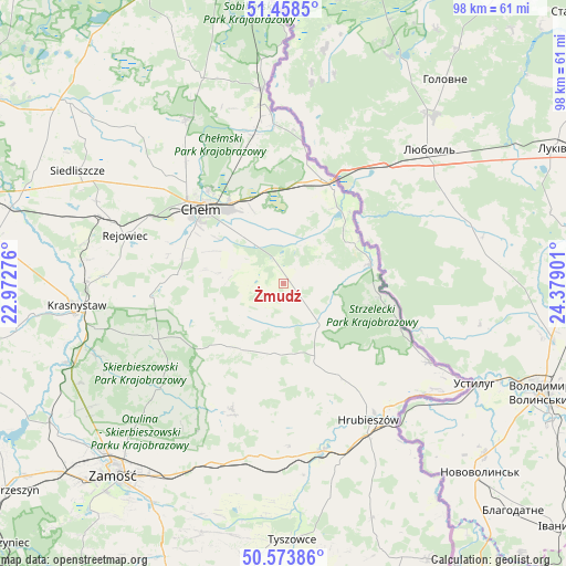
Żmudź GPS coordinates[2]
51° 1' 5.844" North, 23° 40' 33.168" East
| Map corner | latitude | longitude |
|---|---|---|
| Upper-left | 51.4585°, | 22.97276° |
| Center: | 51.01829°, | 23.67588° |
| Lower-right: | 50.57386°, | 24.37901° |
| Map W x H: | 98.4×98.4 km | = 61.1×61.1mi |
| max Lat: | 54.83135° ⇑55% North |
| Żmudź: | 51.01829° |
| min Lat: | ⇓45% South 49.21328° |
| min Long | Żmudź | max Long |
| 14.20249° | 23.67588° | 24.03723° |
| W 99.5%⇐ | ⇒0.5% E |
Elevation
Elevation of Żmudź is 202 m = 663 ft, and this is 10.6 m = 35 ft above average elevation for this country.
| Max E: |
974 m = 3196 ft | 39.4% |
| Żmudź | 202 m 663 ft | |
| Avg. | 191.4 m = 628 ft | |
Min E: |
-3 m = -10 ft | 60.6% |
See also: Poland elevation on elevation.city.
Geographical zone
Żmudź is located in North temperate zone (between Tropic of Cancer and the Arctic Circle). Distance of this North polar circle is 1728.5 km =1074 mi to North.| Distance of | km | miles | from Żmudź |
|---|---|---|---|
| North Pole | 4334.4 | 2693.3 | to North |
| Arctic Circle | 1728.5 | 1074 | to North |
| Tropic Cancer | 3066.8 | 1905.6 | to South |
| Equator | 5672.7 | 3524.9 | to South |


Nearby cities:
15 places around Żmudź: (largest is in red/bold)
• Białopole
5.3 km =3.3 mi,  132°
132°
• Chełm
19.9 km =12.4 mi,  314°
314°
• Dorohusk
17.6 km =10.9 mi,  30°
30°
• Dorohusk-Osada
18.8 km =11.7 mi, 25°
• Dubienka
15.5 km =9.6 mi,  77°
77°
• Grabowiec
23.6 km =14.7 mi,  201°
201°
• Jarosławiec
12.4 km =7.7 mi,  172°
172°
• Kamień
10.7 km =6.6 mi,  323°
323°
• Kraśniczyn
24.8 km =15.4 mi,  247°
247°
• Pokrówka
17.1 km =10.6 mi,  299°
299°
• Siennica Różana
24.8 km =15.4 mi,  265°
265°
• Trzeszczany
22.3 km =13.9 mi, 168°
• Uchanie
12.2 km =7.6 mi,  188°
188°
• Wojsławice
14.3 km =8.9 mi,  219°
219°
• Świerże
22.5 km =14 mi,  10°
10°
Sources, notices
• [Note1] Compared only with cities in Poland existing in our database
• [Src1] Map data: © OpenStreetMap contributors (CC-BY-SA)
• [Src2] Other city data from geonames.org with taken over terms of usage.
• [Src3] Geographical zone / Annual Mean Temperature by Robert A. Rohde @ Wikipedia
