Głuchów geodata
Głuchów (Łódź Voivodeship) is a seat of a third-order administrative division; located in Poland in Europe/Warsaw (GMT+2) time zone. With population of 1,000 people, there are 2459 cities with bigger population in this country. Compared to other cities in Poland, 61.7% of cities are located further ↓South; 59.4% of cities are located further ←West and 52.1% of cities have higher elevation than Głuchów. Note1
Administrative division(s):
- Level 1: Łódź Voivodeship
- Level 2: Powiat skierniewicki
- Level 3: Głuchów


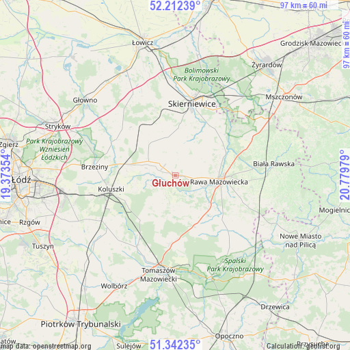
Głuchów GPS coordinates[2]
51° 46' 46.092" North, 20° 4' 35.976" East
| Map corner | latitude | longitude |
|---|---|---|
| Upper-left | 52.21239°, | 19.37354° |
| Center: | 51.77947°, | 20.07666° |
| Lower-right: | 51.34235°, | 20.77979° |
| Map W x H: | 96.7×96.7 km | = 60.1×60.1mi |
| max Lat: | 54.83135° ⇑38.3% North |
| Głuchów: | 51.77947° |
| min Lat: | ⇓61.7% South 49.21328° |
| min Long | Głuchów | max Long |
| 14.20249° | 20.07666° | 24.03723° |
| W 59.4%⇐ | ⇒40.6% E |
Elevation
Elevation of Głuchów is 166 m = 545 ft, and this is 25.4 m = 83 ft below average elevation for this country.
| Max E: |
974 m = 3196 ft | 52.1% |
| Avg. | 191.4 m = 628 ft | |
| Głuchów | 166 m = 545 ft | |
Min E: |
-3 m = -10 ft | 47.9% |
See also: Poland elevation on elevation.city.
Geographical zone
Głuchów is located in North temperate zone (between Tropic of Cancer and the Arctic Circle). Distance of this North polar circle is 1643.8 km =1021.4 mi to North.| Distance of | km | miles | from Głuchów |
|---|---|---|---|
| North Pole | 4249.7 | 2640.6 | to North |
| Arctic Circle | 1643.8 | 1021.4 | to North |
| Tropic Cancer | 3151.4 | 1958.2 | to South |
| Equator | 5757.3 | 3577.4 | to South |


Nearby cities:
15 places around Głuchów: (largest is in red/bold)
• Budziszewice
15.8 km =9.8 mi,  217°
217°
• Cielądz
19.7 km =12.2 mi,  111°
111°
• Czerniewice
15 km =9.3 mi,  158°
158°
• Godzianów
13.4 km =8.3 mi,  347°
347°
• Jeżów
8.3 km =5.2 mi,  297°
297°
• Kawęczyn Nowy
16.7 km =10.4 mi,  44°
44°
• Koluszki
18.2 km =11.3 mi,  255°
255°
• Lipce Reymontowskie
16.2 km =10.1 mi,  325°
325°
• Lubochnia
19.1 km =11.9 mi,  184°
184°
• Maków
18.7 km =11.6 mi, 354°
• Rawa Mazowiecka
12.4 km =7.7 mi,  97°
97°
• Rogów
13.7 km =8.5 mi,  287°
287°
• Słupia
11.2 km =7 mi,  318°
318°
• Złota
5.7 km =3.5 mi, 98°
• Żelechlinek
8 km =5 mi,  201°
201°
Sources, notices
• [Note1] Compared only with cities in Poland existing in our database
• [Src1] Map data: © OpenStreetMap contributors (CC-BY-SA)
• [Src2] Other city data from geonames.org with taken over terms of usage.
• [Src3] Geographical zone / Annual Mean Temperature by Robert A. Rohde @ Wikipedia
