Jeżów geodata
Jeżów (Łódź Voivodeship) is a seat of a third-order administrative division; located in Poland in Europe/Warsaw (GMT+2) time zone. With population of 1,400 people, there are 1959 cities with bigger population in this country. Compared to other cities in Poland, 62.4% of cities are located further ↓South; 57.8% of cities are located further ←West and 55.2% of cities have lower elevation than Jeżów. Note1


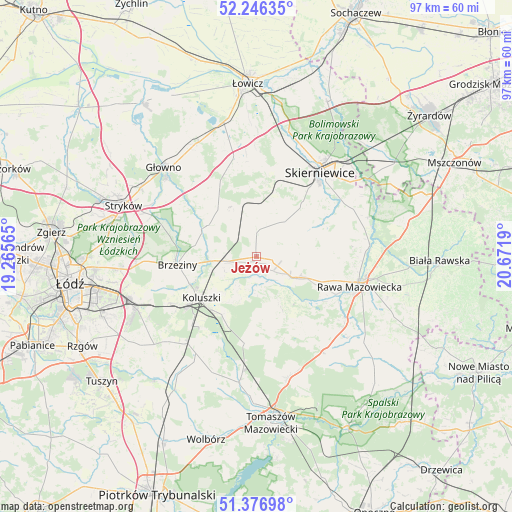
Jeżów GPS coordinates[2]
51° 48' 49.536" North, 19° 58' 7.572" East
| Map corner | latitude | longitude |
|---|---|---|
| Upper-left | 52.24635°, | 19.26565° |
| Center: | 51.81376°, | 19.96877° |
| Lower-right: | 51.37698°, | 20.6719° |
| Map W x H: | 96.7×96.7 km | = 60.1×60.1mi |
| max Lat: | 54.83135° ⇑37.6% North |
| Jeżów: | 51.81376° |
| min Lat: | ⇓62.4% South 49.21328° |
| min Long | Jeżów | max Long |
| 14.20249° | 19.96877° | 24.03723° |
| W 57.8%⇐ | ⇒42.2% E |
Elevation
Elevation of Jeżów is 186 m = 610 ft, and this is 5.4 m = 18 ft below average elevation for this country.
| Max E: |
974 m = 3196 ft | 44.8% |
| Avg. | 191.4 m = 628 ft | |
| Jeżów | 186 m = 610 ft | |
Min E: |
-3 m = -10 ft | 55.2% |
See also: Poland elevation on elevation.city.
Geographical zone
Jeżów is located in North temperate zone (between Tropic of Cancer and the Arctic Circle). Distance of this North polar circle is 1640 km =1019 mi to North.| Distance of | km | miles | from Jeżów |
|---|---|---|---|
| North Pole | 4245.9 | 2638.3 | to North |
| Arctic Circle | 1640 | 1019 | to North |
| Tropic Cancer | 3155.2 | 1960.5 | to South |
| Equator | 5761.2 | 3579.8 | to South |


Nearby cities:
15 places around Jeżów: (largest is in red/bold)
• Brzeziny
15 km =9.3 mi,  264°
264°
• Budziszewice
16.4 km =10.2 mi,  187°
187°
• Dmosin
18.9 km =11.7 mi,  310°
310°
• Gałków Duży
18.9 km =11.7 mi,  242°
242°
• Gałków Mały
20.1 km =12.5 mi, 240°
• Godzianów
10.3 km =6.4 mi,  26°
26°
• Głuchów
8.3 km =5.2 mi,  117°
117°
• Koluszki
13.2 km =8.2 mi,  230°
230°
• Lipce Reymontowskie
9.6 km =6 mi,  348°
348°
• Maków
15.9 km =9.9 mi,  21°
21°
• Rogów
5.7 km =3.5 mi,  274°
274°
• Słupia
4.6 km =2.9 mi,  1°
1°
• Złota
13.8 km =8.6 mi,  109°
109°
• Łyszkowice
19.6 km =12.2 mi, 347°
• Żelechlinek
12.2 km =7.6 mi,  158°
158°
Sources, notices
• [Note1] Compared only with cities in Poland existing in our database
• [Src1] Map data: © OpenStreetMap contributors (CC-BY-SA)
• [Src2] Other city data from geonames.org with taken over terms of usage.
• [Src3] Geographical zone / Annual Mean Temperature by Robert A. Rohde @ Wikipedia
