Rogów geodata
Rogów (Łódź Voivodeship) is a seat of a third-order administrative division; located in Poland in Europe/Warsaw (GMT+2) time zone. With population of 1,500 people, there are 1837 cities with bigger population in this country. Compared to other cities in Poland, 62.4% of cities are located further ↓South; 56.6% of cities are located further ←West and 60% of cities have lower elevation than Rogów. Note1


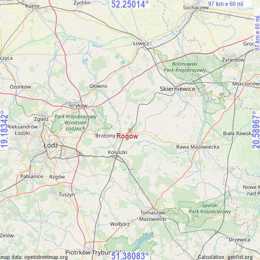
Rogów GPS coordinates[2]
51° 49' 3.288" North, 19° 53' 11.544" East
| Map corner | latitude | longitude |
|---|---|---|
| Upper-left | 52.25014°, | 19.18342° |
| Center: | 51.81758°, | 19.88654° |
| Lower-right: | 51.38083°, | 20.58967° |
| Map W x H: | 96.7×96.7 km | = 60.1×60.1mi |
| max Lat: | 54.83135° ⇑37.6% North |
| Rogów: | 51.81758° |
| min Lat: | ⇓62.4% South 49.21328° |
| min Long | Rogów | max Long |
| 14.20249° | 19.88654° | 24.03723° |
| W 56.6%⇐ | ⇒43.4% E |
Elevation
Elevation of Rogów is 200 m = 656 ft, and this is 8.6 m = 28 ft above average elevation for this country.
| Max E: |
974 m = 3196 ft | 40% |
| Rogów | 200 m 656 ft | |
| Avg. | 191.4 m = 628 ft | |
Min E: |
-3 m = -10 ft | 60% |
See also: Poland elevation on elevation.city.
Geographical zone
Rogów is located in North temperate zone (between Tropic of Cancer and the Arctic Circle). Distance of this North polar circle is 1639.6 km =1018.8 mi to North.| Distance of | km | miles | from Rogów |
|---|---|---|---|
| North Pole | 4245.5 | 2638 | to North |
| Arctic Circle | 1639.6 | 1018.8 | to North |
| Tropic Cancer | 3155.7 | 1960.9 | to South |
| Equator | 5761.6 | 3580.1 | to South |


Nearby cities:
15 places around Rogów: (largest is in red/bold)
• Brzeziny
9.5 km =5.9 mi,  258°
258°
• Budziszewice
17 km =10.6 mi,  168°
168°
• Dmosin
14.7 km =9.1 mi,  323°
323°
• Gałków Duży
14.4 km =8.9 mi,  230°
230°
• Gałków Mały
15.7 km =9.8 mi, 229°
• Godzianów
13.5 km =8.4 mi,  49°
49°
• Głuchów
13.7 km =8.5 mi,  107°
107°
• Jeżów
5.7 km =3.5 mi,  94°
94°
• Koluszki
9.9 km =6.2 mi,  207°
207°
• Lipce Reymontowskie
9.8 km =6.1 mi,  22°
22°
• Maków
18.3 km =11.4 mi,  38°
38°
• Rokiciny-Kolonia
18.4 km =11.4 mi,  202°
202°
• Słupia
7.1 km =4.4 mi, 53°
• Łyszkowice
18.7 km =11.6 mi,  4°
4°
• Żelechlinek
15.5 km =9.6 mi,  139°
139°
Sources, notices
• [Note1] Compared only with cities in Poland existing in our database
• [Src1] Map data: © OpenStreetMap contributors (CC-BY-SA)
• [Src2] Other city data from geonames.org with taken over terms of usage.
• [Src3] Geographical zone / Annual Mean Temperature by Robert A. Rohde @ Wikipedia
