Łoniów geodata
Łoniów (Świętokrzyskie) is a seat of a third-order administrative division; located in Poland in Europe/Warsaw (GMT+2) time zone. With population of 450 people, there are 3564 cities with bigger population in this country. Compared to other cities in Poland, 66.1% of cities are located further ↑North; 79.3% of cities are located further ←West and 50.2% of cities have lower elevation than Łoniów. Note1


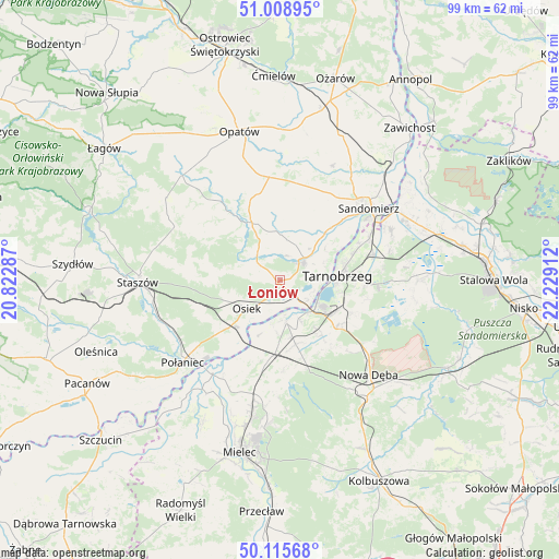
Łoniów GPS coordinates[2]
50° 33' 51.948" North, 21° 31' 33.564" East
| Map corner | latitude | longitude |
|---|---|---|
| Upper-left | 51.00895°, | 20.82287° |
| Center: | 50.56443°, | 21.52599° |
| Lower-right: | 50.11568°, | 22.22912° |
| Map W x H: | 99.3×99.3 km | = 61.7×61.7mi |
| max Lat: | 54.83135° ⇑66.1% North |
| Łoniów: | 50.56443° |
| min Lat: | ⇓33.9% South 49.21328° |
| min Long | Łoniów | max Long |
| 14.20249° | 21.52599° | 24.03723° |
| W 79.3%⇐ | ⇒20.7% E |
Elevation
Elevation of Łoniów is 172 m = 564 ft, and this is 19.4 m = 64 ft below average elevation for this country.
| Max E: |
974 m = 3196 ft | 49.8% |
| Avg. | 191.4 m = 628 ft | |
| Łoniów | 172 m = 564 ft | |
Min E: |
-3 m = -10 ft | 50.2% |
See also: Poland elevation on elevation.city.
Geographical zone
Łoniów is located in North temperate zone (between Tropic of Cancer and the Arctic Circle). Distance of this North polar circle is 1778.9 km =1105.4 mi to North.| Distance of | km | miles | from Łoniów |
|---|---|---|---|
| North Pole | 4384.8 | 2724.6 | to North |
| Arctic Circle | 1778.9 | 1105.4 | to North |
| Tropic Cancer | 3016.3 | 1874.2 | to South |
| Equator | 5622.2 | 3493.5 | to South |


Nearby cities:
15 places around Łoniów: (largest is in red/bold)
• Baranów Sandomierski
7.3 km =4.5 mi,  171°
171°
• Bogoria
21.1 km =13.1 mi,  297°
297°
• Gawłuszowice
19.6 km =12.2 mi,  211°
211°
• Klimontów
11.3 km =7 mi,  334°
334°
• Koprzywnica
5.2 km =3.2 mi,  51°
51°
• Lipnik
18.5 km =11.5 mi,  352°
352°
• Obrazów
16.8 km =10.4 mi,  31°
31°
• Osiek
7.7 km =4.8 mi,  230°
230°
• Padew Narodowa
14 km =8.7 mi,  187°
187°
• Samborzec
12.6 km =7.8 mi,  43°
43°
• Sandomierz
20.5 km =12.7 mi, 50°
• Tarnobrzeg
10.9 km =6.8 mi,  84°
84°
• Wiśniowa
19.6 km =12.2 mi,  279°
279°
• Złota
15.5 km =9.6 mi, 45°
• Świniary Stare
3 km =1.9 mi, 173°
Sources, notices
• [Note1] Compared only with cities in Poland existing in our database
• [Src1] Map data: © OpenStreetMap contributors (CC-BY-SA)
• [Src2] Other city data from geonames.org with taken over terms of usage.
• [Src3] Geographical zone / Annual Mean Temperature by Robert A. Rohde @ Wikipedia
