Dubeninki geodata
Dubeninki (Warmia-Masuria) is a populated place; located in Poland in Europe/Warsaw (GMT+2) time zone. With population of 962 people, there are 2565 cities with bigger population in this country. Compared to other cities in Poland, 97.5% of cities are located further ↓South; 92.3% of cities are located further ←West and 65.3% of cities have lower elevation than Dubeninki. Note1


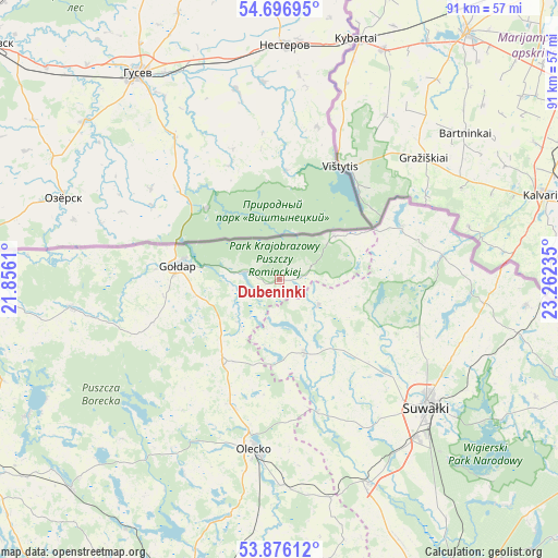
Dubeninki GPS coordinates[2]
54° 17' 18.888" North, 22° 33' 33.192" East
| Map corner | latitude | longitude |
|---|---|---|
| Upper-left | 54.69695°, | 21.8561° |
| Center: | 54.28858°, | 22.55922° |
| Lower-right: | 53.87612°, | 23.26235° |
| Map W x H: | 91.3×91.3 km | = 56.7×56.7mi |
| max Lat: | 54.83135° ⇑2.5% North |
| Dubeninki: | 54.28858° |
| min Lat: | ⇓97.5% South 49.21328° |
| min Long | Dubeninki | max Long |
| 14.20249° | 22.55922° | 24.03723° |
| W 92.3%⇐ | ⇒7.7% E |
Elevation
Elevation of Dubeninki is 215 m = 705 ft, and this is 23.6 m = 77 ft above average elevation for this country.
| Max E: |
974 m = 3196 ft | 34.7% |
| Dubeninki | 215 m 705 ft | |
| Avg. | 191.4 m = 628 ft | |
Min E: |
-3 m = -10 ft | 65.3% |
See also: Poland elevation on elevation.city.
Geographical zone
Dubeninki is located in North temperate zone (between Tropic of Cancer and the Arctic Circle). Distance of this North polar circle is 1364.8 km =848 mi to North.| Distance of | km | miles | from Dubeninki |
|---|---|---|---|
| North Pole | 3970.7 | 2467.3 | to North |
| Arctic Circle | 1364.8 | 848 | to North |
| Tropic Cancer | 3430.4 | 2131.6 | to South |
| Equator | 6036.3 | 3750.8 | to South |


Nearby cities:
15 places around Dubeninki: (largest is in red/bold)
• Bakałarzewo
22.5 km =14 mi,  164°
164°
• Banie Mazurskie
34.3 km =21.3 mi,  262°
262°
• Filipów
12.7 km =7.9 mi, 161°
• Gołdap
16.7 km =10.4 mi,  276°
276°
• Grabowo
21.8 km =13.5 mi,  251°
251°
• Jeleniewo
24.7 km =15.3 mi,  111°
111°
• Kowale Oleckie
16.7 km =10.4 mi,  213°
213°
• Olecko
28.5 km =17.7 mi,  186°
186°
• Przerośl
7.6 km =4.7 mi,  122°
122°
• Puńsk
40.6 km =25.2 mi,  95°
95°
• Raczki
36.6 km =22.7 mi, 156°
• Suwałki
31.2 km =19.4 mi,  129°
129°
• Swiętajno
35.6 km =22.1 mi, 206°
• Wieliczki
33.8 km =21 mi,  179°
179°
• Wiżajny
21.9 km =13.6 mi,  66°
66°
Sources, notices
• [Note1] Compared only with cities in Poland existing in our database
• [Src1] Map data: © OpenStreetMap contributors (CC-BY-SA)
• [Src2] Other city data from geonames.org with taken over terms of usage.
• [Src3] Geographical zone / Annual Mean Temperature by Robert A. Rohde @ Wikipedia
