Bakałarzewo geodata
Bakałarzewo (Podlasie) is a populated place; located in Poland in Europe/Warsaw (GMT+2) time zone. With population of 890 people, there are 2695 cities with bigger population in this country. Compared to other cities in Poland, 95.2% of cities are located further ↓South; 93.3% of cities are located further ←West and 50.8% of cities have lower elevation than Bakałarzewo. Note1


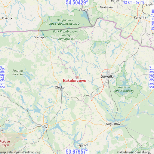
Bakałarzewo GPS coordinates[2]
54° 5' 38.328" North, 22° 39' 7.848" East
| Map corner | latitude | longitude |
|---|---|---|
| Upper-left | 54.50429°, | 21.94906° |
| Center: | 54.09398°, | 22.65218° |
| Lower-right: | 53.67957°, | 23.35531° |
| Map W x H: | 91.7×91.7 km | = 57×57mi |
| max Lat: | 54.83135° ⇑4.8% North |
| Bakałarzewo: | 54.09398° |
| min Lat: | ⇓95.2% South 49.21328° |
| min Long | Bakałarzewo | max Long |
| 14.20249° | 22.65218° | 24.03723° |
| W 93.3%⇐ | ⇒6.7% E |
Elevation
Elevation of Bakałarzewo is 174 m = 571 ft, and this is 17.4 m = 57 ft below average elevation for this country.
| Max E: |
974 m = 3196 ft | 49.2% |
| Avg. | 191.4 m = 628 ft | |
| Bakałarzewo | 174 m = 571 ft | |
Min E: |
-3 m = -10 ft | 50.8% |
See also: Poland elevation on elevation.city.
Geographical zone
Bakałarzewo is located in North temperate zone (between Tropic of Cancer and the Arctic Circle). Distance of this North polar circle is 1386.5 km =861.5 mi to North.| Distance of | km | miles | from Bakałarzewo |
|---|---|---|---|
| North Pole | 3992.4 | 2480.8 | to North |
| Arctic Circle | 1386.5 | 861.5 | to North |
| Tropic Cancer | 3408.8 | 2118.1 | to South |
| Equator | 6014.7 | 3737.4 | to South |


Nearby cities:
15 places around Bakałarzewo: (largest is in red/bold)
• Dubeninki
22.5 km =14 mi,  344°
344°
• Ełk
35 km =21.7 mi,  212°
212°
• Filipów
9.8 km =6.1 mi,  347°
347°
• Gołdap
32.7 km =20.3 mi,  316°
316°
• Grabowo
30.5 km =19 mi,  298°
298°
• Jeleniewo
21 km =13 mi,  53°
53°
• Kalinowo
24.4 km =15.2 mi,  176°
176°
• Kowale Oleckie
17.2 km =10.7 mi, 296°
• Olecko
11.6 km =7.2 mi,  234°
234°
• Przerośl
17.6 km =10.9 mi,  1°
1°
• Raczki
14.7 km =9.1 mi,  143°
143°
• Suwałki
18.3 km =11.4 mi,  83°
83°
• Swiętajno
24.1 km =15 mi,  244°
244°
• Wieliczki
13.5 km =8.4 mi, 205°
• Wiżajny
33.5 km =20.8 mi,  24°
24°
Sources, notices
• [Note1] Compared only with cities in Poland existing in our database
• [Src1] Map data: © OpenStreetMap contributors (CC-BY-SA)
• [Src2] Other city data from geonames.org with taken over terms of usage.
• [Src3] Geographical zone / Annual Mean Temperature by Robert A. Rohde @ Wikipedia
