Jeleniewo geodata
Jeleniewo (Podlasie) is a populated place; located in Poland in Europe/Warsaw (GMT+2) time zone. With population of 614 people, there are 3242 cities with bigger population in this country. Compared to other cities in Poland, 96.3% of cities are located further ↓South; 95.3% of cities are located further ←West and 65.3% of cities have lower elevation than Jeleniewo. Note1


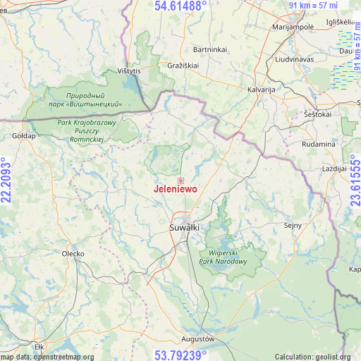
Jeleniewo GPS coordinates[2]
54° 12' 20.448" North, 22° 54' 44.712" East
| Map corner | latitude | longitude |
|---|---|---|
| Upper-left | 54.61488°, | 22.2093° |
| Center: | 54.20568°, | 22.91242° |
| Lower-right: | 53.79239°, | 23.61555° |
| Map W x H: | 91.5×91.5 km | = 56.9×56.9mi |
| max Lat: | 54.83135° ⇑3.7% North |
| Jeleniewo: | 54.20568° |
| min Lat: | ⇓96.3% South 49.21328° |
| min Long | Jeleniewo | max Long |
| 14.20249° | 22.91242° | 24.03723° |
| W 95.3%⇐ | ⇒4.7% E |
Elevation
Elevation of Jeleniewo is 215 m = 705 ft, and this is 23.6 m = 77 ft above average elevation for this country.
| Max E: |
974 m = 3196 ft | 34.7% |
| Jeleniewo | 215 m 705 ft | |
| Avg. | 191.4 m = 628 ft | |
Min E: |
-3 m = -10 ft | 65.3% |
See also: Poland elevation on elevation.city.
Geographical zone
Jeleniewo is located in North temperate zone (between Tropic of Cancer and the Arctic Circle). Distance of this North polar circle is 1374.1 km =853.8 mi to North.| Distance of | km | miles | from Jeleniewo |
|---|---|---|---|
| North Pole | 3980 | 2473.1 | to North |
| Arctic Circle | 1374.1 | 853.8 | to North |
| Tropic Cancer | 3421.2 | 2125.8 | to South |
| Equator | 6027.1 | 3745.1 | to South |


Nearby cities:
15 places around Jeleniewo: (largest is in red/bold)
• Bakałarzewo
21 km =13 mi,  233°
233°
• Dubeninki
24.7 km =15.3 mi,  291°
291°
• Filipów
19.2 km =11.9 mi,  261°
261°
• Giby
34.1 km =21.2 mi,  122°
122°
• Kalinowo
40 km =24.9 mi,  203°
203°
• Kowale Oleckie
32.6 km =20.3 mi, 261°
• Krasnopol
21.5 km =13.4 mi, 117°
• Olecko
32.6 km =20.3 mi, 234°
• Przerośl
17.3 km =10.7 mi, 287°
• Puńsk
18.2 km =11.3 mi,  73°
73°
• Raczki
25.6 km =15.9 mi, 198°
• Sejny
30.3 km =18.8 mi,  110°
110°
• Suwałki
10.5 km =6.5 mi,  173°
173°
• Wieliczki
33.6 km =20.9 mi,  222°
222°
• Wiżajny
18.2 km =11.3 mi,  350°
350°
Sources, notices
• [Note1] Compared only with cities in Poland existing in our database
• [Src1] Map data: © OpenStreetMap contributors (CC-BY-SA)
• [Src2] Other city data from geonames.org with taken over terms of usage.
• [Src3] Geographical zone / Annual Mean Temperature by Robert A. Rohde @ Wikipedia
