Puńsk geodata
Puńsk (Podlasie) is a populated place; located in Poland in Europe/Warsaw (GMT+2) time zone. With population of 1,210 people, there are 2157 cities with bigger population in this country. Compared to other cities in Poland, 97% of cities are located further ↓South; 97.3% of cities are located further ←West and 51.6% of cities have higher elevation than Puńsk. Note1


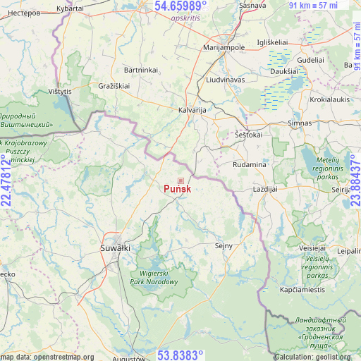
Puńsk GPS coordinates[2]
54° 15' 4.104" North, 23° 10' 52.464" East
| Map corner | latitude | longitude |
|---|---|---|
| Upper-left | 54.65989°, | 22.47812° |
| Center: | 54.25114°, | 23.18124° |
| Lower-right: | 53.8383°, | 23.88437° |
| Map W x H: | 91.4×91.3 km | = 56.8×56.7mi |
| max Lat: | 54.83135° ⇑3% North |
| Puńsk: | 54.25114° |
| min Lat: | ⇓97% South 49.21328° |
| min Long | Puńsk | max Long |
| 14.20249° | 23.18124° | 24.03723° |
| W 97.3%⇐ | ⇒2.7% E |
Elevation
Elevation of Puńsk is 168 m = 551 ft, and this is 23.4 m = 77 ft below average elevation for this country.
| Max E: |
974 m = 3196 ft | 51.6% |
| Avg. | 191.4 m = 628 ft | |
| Puńsk | 168 m = 551 ft | |
Min E: |
-3 m = -10 ft | 48.4% |
See also: Poland elevation on elevation.city.
Geographical zone
Puńsk is located in North temperate zone (between Tropic of Cancer and the Arctic Circle). Distance of this North polar circle is 1369 km =850.7 mi to North.| Distance of | km | miles | from Puńsk |
|---|---|---|---|
| North Pole | 3974.9 | 2469.9 | to North |
| Arctic Circle | 1369 | 850.7 | to North |
| Tropic Cancer | 3426.2 | 2128.9 | to South |
| Equator | 6032.2 | 3748.2 | to South |


Nearby cities:
15 places around Puńsk: (largest is in red/bold)
• Augustów
47.2 km =29.3 mi,  196°
196°
• Bakałarzewo
38.6 km =24 mi,  243°
243°
• Dubeninki
40.6 km =25.2 mi,  275°
275°
• Filipów
37.3 km =23.2 mi,  257°
257°
• Giby
25.8 km =16 mi,  153°
153°
• Jeleniewo
18.2 km =11.3 mi,  253°
253°
• Kowale Oleckie
50.7 km =31.5 mi, 258°
• Krasnopol
15.1 km =9.4 mi,  174°
174°
• Olecko
50.1 km =31.1 mi, 241°
• Przerośl
34 km =21.1 mi,  270°
270°
• Raczki
39.1 km =24.3 mi,  221°
221°
• Sejny
19.2 km =11.9 mi, 145°
• Suwałki
22.5 km =14 mi,  226°
226°
• Wieliczki
50.1 km =31.1 mi, 233°
• Wiżajny
24.1 km =15 mi,  302°
302°
Sources, notices
• [Note1] Compared only with cities in Poland existing in our database
• [Src1] Map data: © OpenStreetMap contributors (CC-BY-SA)
• [Src2] Other city data from geonames.org with taken over terms of usage.
• [Src3] Geographical zone / Annual Mean Temperature by Robert A. Rohde @ Wikipedia
