Raczki geodata
Raczki (Podlasie) is a populated place; located in Poland in Europe/Warsaw (GMT+2) time zone. With population of 2,322 people, there are 1316 cities with bigger population in this country. Compared to other cities in Poland, 94% of cities are located further ↓South; 94.5% of cities are located further ←West and 54.2% of cities have higher elevation than Raczki. Note1


Raczki GPS coordinates[2]
53° 59' 14.964" North, 22° 47' 5.532" East
| Map corner | latitude | longitude |
|---|---|---|
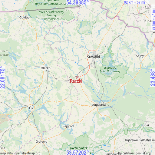
| Upper-left | 54.39885°, | 22.08175° |
| Center: | 53.98749°, | 22.78487° |
| Lower-right: | 53.57202°, | 23.488° |
| Map W x H: | 91.9×91.9 km | = 57.1×57.1mi |
| max Lat: | 54.83135° ⇑6% North |
| Raczki: | 53.98749° |
| min Lat: | ⇓94% South 49.21328° |
| min Long | Raczki | max Long |
| 14.20249° | 22.78487° | 24.03723° |
| W 94.5%⇐ | ⇒5.5% E |
Elevation
Elevation of Raczki is 161 m = 528 ft, and this is 30.4 m = 100 ft below average elevation for this country.
| Max E: |
974 m = 3196 ft | 54.2% |
| Avg. | 191.4 m = 628 ft | |
| Raczki | 161 m = 528 ft | |
Min E: |
-3 m = -10 ft | 45.8% |
See also: Poland elevation on elevation.city.
Geographical zone
Raczki is located in North temperate zone (between Tropic of Cancer and the Arctic Circle). Distance of this North polar circle is 1398.3 km =868.9 mi to North.| Distance of | km | miles | from Raczki |
|---|---|---|---|
| North Pole | 4004.2 | 2488.1 | to North |
| Arctic Circle | 1398.3 | 868.9 | to North |
| Tropic Cancer | 3396.9 | 2110.7 | to South |
| Equator | 6002.8 | 3730 | to South |


Nearby cities:
15 places around Raczki: (largest is in red/bold)
• Augustów
20.5 km =12.7 mi,  141°
141°
• Bakałarzewo
14.7 km =9.1 mi,  323°
323°
• Bargłów Kościelny
23.9 km =14.9 mi,  174°
174°
• Ełk
32.7 km =20.3 mi,  237°
237°
• Filipów
24 km =14.9 mi,  333°
333°
• Jeleniewo
25.6 km =15.9 mi,  18°
18°
• Kalinowo
14.6 km =9.1 mi,  210°
210°
• Kowale Oleckie
31 km =19.3 mi,  309°
309°
• Krasnopol
30.9 km =19.2 mi,  62°
62°
• Olecko
18.9 km =11.7 mi,  285°
285°
• Przerośl
30.5 km =19 mi,  344°
344°
• Rajgród
29 km =18 mi,  190°
190°
• Suwałki
16.8 km =10.4 mi,  34°
34°
• Swiętajno
30.5 km =19 mi,  272°
272°
• Wieliczki
14.6 km =9.1 mi, 268°
Sources, notices
• [Note1] Compared only with cities in Poland existing in our database
• [Src1] Map data: © OpenStreetMap contributors (CC-BY-SA)
• [Src2] Other city data from geonames.org with taken over terms of usage.
• [Src3] Geographical zone / Annual Mean Temperature by Robert A. Rohde @ Wikipedia
