Niedrzwica Duża geodata
Niedrzwica Duża (Lublin) is a seat of a third-order administrative division; located in Poland in Europe/Warsaw (GMT+2) time zone. With population of 3,900 people, there are 834 cities with bigger population in this country. Compared to other cities in Poland, 52.1% of cities are located further ↑North; 90% of cities are located further ←West and 58.3% of cities have lower elevation than Niedrzwica Duża. Note1


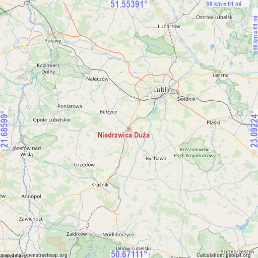
Niedrzwica Duża GPS coordinates[2]
51° 6' 52.632" North, 22° 23' 20.796" East
| Map corner | latitude | longitude |
|---|---|---|
| Upper-left | 51.55391°, | 21.68599° |
| Center: | 51.11462°, | 22.38911° |
| Lower-right: | 50.67111°, | 23.09224° |
| Map W x H: | 98.2×98.2 km | = 61×61mi |
| max Lat: | 54.83135° ⇑52.1% North |
| Niedrzwica Duża: | 51.11462° |
| min Lat: | ⇓47.9% South 49.21328° |
| min Long | Niedrzwica Duż | max Long |
| 14.20249° | 22.38911° | 24.03723° |
| W 90%⇐ | ⇒10% E |
Elevation
Elevation of Niedrzwica Duża is 194 m = 636 ft, and this is 2.6 m = 9 ft above average elevation for this country.
| Max E: |
974 m = 3196 ft | 41.7% |
| Niedrzwica Duża | 194 m 636 ft | |
| Avg. | 191.4 m = 628 ft | |
Min E: |
-3 m = -10 ft | 58.3% |
See also: Poland elevation on elevation.city.
Geographical zone
Niedrzwica Duża is located in North temperate zone (between Tropic of Cancer and the Arctic Circle). Distance of this North polar circle is 1717.8 km =1067.4 mi to North.| Distance of | km | miles | from Niedrzwica Duża |
|---|---|---|---|
| North Pole | 4323.6 | 2686.6 | to North |
| Arctic Circle | 1717.8 | 1067.4 | to North |
| Tropic Cancer | 3077.5 | 1912.3 | to South |
| Equator | 5683.4 | 3531.5 | to South |


Nearby cities:
15 places around Niedrzwica Duża: (largest is in red/bold)
• Bełżyce
10.1 km =6.3 mi,  311°
311°
• Borzechów
7.7 km =4.8 mi,  251°
251°
• Bychawa
14.9 km =9.3 mi,  137°
137°
• Bystrzyca
14 km =8.7 mi,  174°
174°
• Chodel
17.9 km =11.1 mi,  268°
268°
• Jabłonna
14.6 km =9.1 mi,  101°
101°
• Konopnica
13.6 km =8.5 mi,  21°
21°
• Kozubszczyzna
12.4 km =7.7 mi,  12°
12°
• Poniatowa
19.4 km =12.1 mi,  291°
291°
• Rudnik Pierwszy
17.4 km =10.8 mi, 168°
• Strzyżowice
8.2 km =5.1 mi,  154°
154°
• Wilkołaz
11.4 km =7.1 mi,  193°
193°
• Wojciechów
16.8 km =10.4 mi,  323°
323°
• Zakrzówek
18.2 km =11.3 mi,  181°
181°
• Żabia Wola
8.8 km =5.5 mi,  86°
86°
Sources, notices
• [Note1] Compared only with cities in Poland existing in our database
• [Src1] Map data: © OpenStreetMap contributors (CC-BY-SA)
• [Src2] Other city data from geonames.org with taken over terms of usage.
• [Src3] Geographical zone / Annual Mean Temperature by Robert A. Rohde @ Wikipedia
