Borzechów geodata
Borzechów (Lublin) is a seat of a third-order administrative division; located in Poland in Europe/Warsaw (GMT+2) time zone. With population of 390 people, there are 3595 cities with bigger population in this country. Compared to other cities in Poland, 52.8% of cities are located further ↑North; 88.5% of cities are located further ←West and 60% of cities have lower elevation than Borzechów. Note1


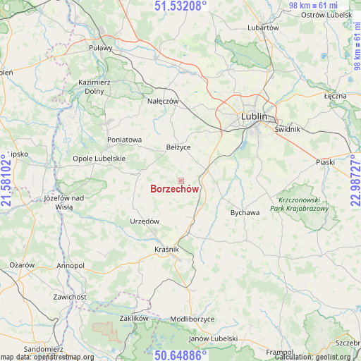
Borzechów GPS coordinates[2]
51° 5' 33.288" North, 22° 17' 2.904" East
| Map corner | latitude | longitude |
|---|---|---|
| Upper-left | 51.53208°, | 21.58102° |
| Center: | 51.09258°, | 22.28414° |
| Lower-right: | 50.64886°, | 22.98727° |
| Map W x H: | 98.2×98.2 km | = 61×61mi |
| max Lat: | 54.83135° ⇑52.8% North |
| Borzechów: | 51.09258° |
| min Lat: | ⇓47.2% South 49.21328° |
| min Long | Borzechów | max Long |
| 14.20249° | 22.28414° | 24.03723° |
| W 88.5%⇐ | ⇒11.5% E |
Elevation
Elevation of Borzechów is 200 m = 656 ft, and this is 8.6 m = 28 ft above average elevation for this country.
| Max E: |
974 m = 3196 ft | 40% |
| Borzechów | 200 m 656 ft | |
| Avg. | 191.4 m = 628 ft | |
Min E: |
-3 m = -10 ft | 60% |
See also: Poland elevation on elevation.city.
Geographical zone
Borzechów is located in North temperate zone (between Tropic of Cancer and the Arctic Circle). Distance of this North polar circle is 1720.2 km =1068.9 mi to North.| Distance of | km | miles | from Borzechów |
|---|---|---|---|
| North Pole | 4326.1 | 2688.1 | to North |
| Arctic Circle | 1720.2 | 1068.9 | to North |
| Tropic Cancer | 3075 | 1910.7 | to South |
| Equator | 5681 | 3530 | to South |


Nearby cities:
15 places around Borzechów: (largest is in red/bold)
• Bełżyce
9.1 km =5.7 mi,  358°
358°
• Bystrzyca
14.4 km =8.9 mi,  142°
142°
• Chodel
10.8 km =6.7 mi,  281°
281°
• Kozubszczyzna
17.6 km =10.9 mi,  34°
34°
• Kraśnik
19.2 km =11.9 mi,  191°
191°
• Niedrzwica Duża
7.7 km =4.8 mi,  71°
71°
• Poniatowa
14.4 km =8.9 mi,  312°
312°
• Rudnik Pierwszy
18.2 km =11.3 mi, 143°
• Strzyżowice
12 km =7.5 mi,  114°
114°
• Urzędów
14.8 km =9.2 mi,  221°
221°
• Wierzbica
14.4 km =8.9 mi,  238°
238°
• Wilkołaz
9.8 km =6.1 mi,  151°
151°
• Wojciechów
16.1 km =10 mi,  350°
350°
• Zakrzówek
17.1 km =10.6 mi,  156°
156°
• Żabia Wola
16.4 km =10.2 mi,  79°
79°
Sources, notices
• [Note1] Compared only with cities in Poland existing in our database
• [Src1] Map data: © OpenStreetMap contributors (CC-BY-SA)
• [Src2] Other city data from geonames.org with taken over terms of usage.
• [Src3] Geographical zone / Annual Mean Temperature by Robert A. Rohde @ Wikipedia
