Czerwonka-Parcel geodata
Czerwonka-Parcel (Mazovia) is a populated place; located in Poland in Europe/Warsaw (GMT+2) time zone. With population of 502 people, there are 3536 cities with bigger population in this country. Compared to other cities in Poland, 70.5% of cities are located further ↓South; 62.1% of cities are located further ←West and 86.1% of cities have higher elevation than Czerwonka-Parcel. Note1


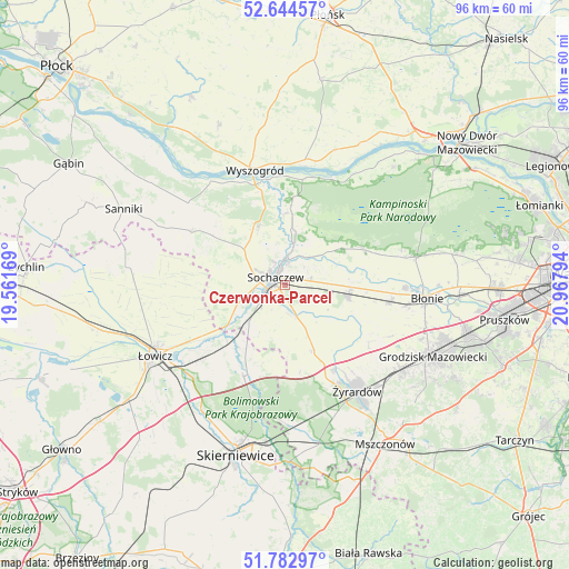
Czerwonka-Parcel GPS coordinates[2]
52° 12' 57.096" North, 20° 15' 53.316" East
| Map corner | latitude | longitude |
|---|---|---|
| Upper-left | 52.64457°, | 19.56169° |
| Center: | 52.21586°, | 20.26481° |
| Lower-right: | 51.78297°, | 20.96794° |
| Map W x H: | 95.8×95.8 km | = 59.5×59.5mi |
| max Lat: | 54.83135° ⇑29.5% North |
| Czerwonka-Parcel: | 52.21586° |
| min Lat: | ⇓70.5% South 49.21328° |
| min Long | Czerwonka-Parce | max Long |
| 14.20249° | 20.26481° | 24.03723° |
| W 62.1%⇐ | ⇒37.9% E |
Elevation
Elevation of Czerwonka-Parcel is 87 m = 285 ft, and this is 104.4 m = 343 ft below average elevation for this country.
| Max E: |
974 m = 3196 ft | 86.1% |
| Avg. | 191.4 m = 628 ft | |
| Czerwonka-Parcel | 87 m = 285 ft | |
Min E: |
-3 m = -10 ft | 13.9% |
See also: Poland elevation on elevation.city.
Geographical zone
Czerwonka-Parcel is located in North temperate zone (between Tropic of Cancer and the Arctic Circle). Distance of this North polar circle is 1595.3 km =991.3 mi to North.| Distance of | km | miles | from Czerwonka-Parcel |
|---|---|---|---|
| North Pole | 4201.2 | 2610.5 | to North |
| Arctic Circle | 1595.3 | 991.3 | to North |
| Tropic Cancer | 3199.9 | 1988.3 | to South |
| Equator | 5805.9 | 3607.6 | to South |


Nearby cities:
15 places around Czerwonka-Parcel: (largest is in red/bold)
• Bolimów
16.9 km =10.5 mi,  204°
204°
• Boża Wola
18 km =11.2 mi,  100°
100°
• Brochów
11.5 km =7.1 mi,  359°
359°
• Guzów
12.1 km =7.5 mi,  156°
156°
• Kampinos
14.7 km =9.1 mi,  66°
66°
• Kocierzew Południowy
16.8 km =10.4 mi,  270°
270°
• Kozłów Biskupi
5.6 km =3.5 mi,  241°
241°
• Miedniewice
15 km =9.3 mi,  170°
170°
• Młodzieszyn
10.3 km =6.4 mi,  334°
334°
• Paprotnia
10.9 km =6.8 mi, 96°
• Rybno
11.4 km =7.1 mi,  285°
285°
• Sochaczew
2.3 km =1.4 mi,  309°
309°
• Teresin
10.5 km =6.5 mi, 100°
• Wiskitki
16.5 km =10.3 mi,  149°
149°
• Wyszogród
20 km =12.4 mi,  345°
345°
Sources, notices
• [Note1] Compared only with cities in Poland existing in our database
• [Src1] Map data: © OpenStreetMap contributors (CC-BY-SA)
• [Src2] Other city data from geonames.org with taken over terms of usage.
• [Src3] Geographical zone / Annual Mean Temperature by Robert A. Rohde @ Wikipedia
