Serock geodata
Serock (Mazovia) is a seat of a third-order administrative division; located in Poland in Europe/Warsaw (GMT+2) time zone. With population of 4,023 people, there are 811 cities with bigger population in this country. Compared to other cities in Poland, 76.6% of cities are located further ↓South; 73.9% of cities are located further ←West and 74.5% of cities have higher elevation than Serock. Note1


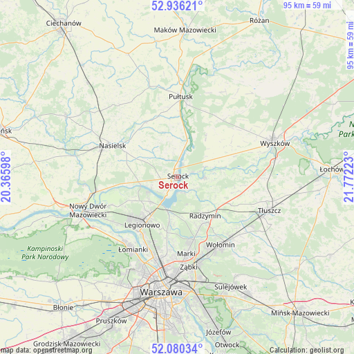
Serock GPS coordinates[2]
52° 30' 37.296" North, 21° 4' 8.76" East
| Map corner | latitude | longitude |
|---|---|---|
| Upper-left | 52.93621°, | 20.36598° |
| Center: | 52.51036°, | 21.0691° |
| Lower-right: | 52.08034°, | 21.77223° |
| Map W x H: | 95.2×95.2 km | = 59.2×59.2mi |
| max Lat: | 54.83135° ⇑23.4% North |
| Serock: | 52.51036° |
| min Lat: | ⇓76.6% South 49.21328° |
| min Long | Serock | max Long |
| 14.20249° | 21.0691° | 24.03723° |
| W 73.9%⇐ | ⇒26.1% E |
Elevation
Elevation of Serock is 112 m = 367 ft, and this is 79.4 m = 260 ft below average elevation for this country.
| Max E: |
974 m = 3196 ft | 74.5% |
| Avg. | 191.4 m = 628 ft | |
| Serock | 112 m = 367 ft | |
Min E: |
-3 m = -10 ft | 25.5% |
See also: Poland elevation on elevation.city.
Geographical zone
Serock is located in North temperate zone (between Tropic of Cancer and the Arctic Circle). Distance of this North polar circle is 1562.6 km =971 mi to North.| Distance of | km | miles | from Serock |
|---|---|---|---|
| North Pole | 4168.5 | 2590.2 | to North |
| Arctic Circle | 1562.6 | 971 | to North |
| Tropic Cancer | 3232.7 | 2008.7 | to South |
| Equator | 5838.6 | 3627.9 | to South |


Nearby cities:
15 places around Serock: (largest is in red/bold)
• Białobrzegi
7.7 km =4.8 mi,  188°
188°
• Dąbrówka
15.8 km =9.8 mi,  100°
100°
• Legionowo
15.5 km =9.6 mi,  218°
218°
• Michałów-Reginów
12.5 km =7.8 mi,  213°
213°
• Nieporęt
9.1 km =5.7 mi,  195°
195°
• Pokrzywnica
12.7 km =7.9 mi,  344°
344°
• Radzymin
13.1 km =8.1 mi,  143°
143°
• Somianka
16.2 km =10.1 mi,  69°
69°
• Stanisławów
13.1 km =8.1 mi, 212°
• Stanisławów Pierwszy
15.1 km =9.4 mi,  184°
184°
• Słupno
15.2 km =9.4 mi,  157°
157°
• Wieliszew
9.5 km =5.9 mi,  226°
226°
• Winnica
17.1 km =10.6 mi,  329°
329°
• Zatory
12.5 km =7.8 mi,  37°
37°
• Łajski
12.2 km =7.6 mi, 221°
Sources, notices
• [Note1] Compared only with cities in Poland existing in our database
• [Src1] Map data: © OpenStreetMap contributors (CC-BY-SA)
• [Src2] Other city data from geonames.org with taken over terms of usage.
• [Src3] Geographical zone / Annual Mean Temperature by Robert A. Rohde @ Wikipedia
