Mogielnica geodata
Mogielnica (Mazovia) is a seat of a third-order administrative division; located in Poland in Europe/Warsaw (GMT+2) time zone. With population of 2,453 people, there are 1268 cities with bigger population in this country. Compared to other cities in Poland, 60% of cities are located further ↓South; 68.1% of cities are located further ←West and 64.4% of cities have higher elevation than Mogielnica. Note1


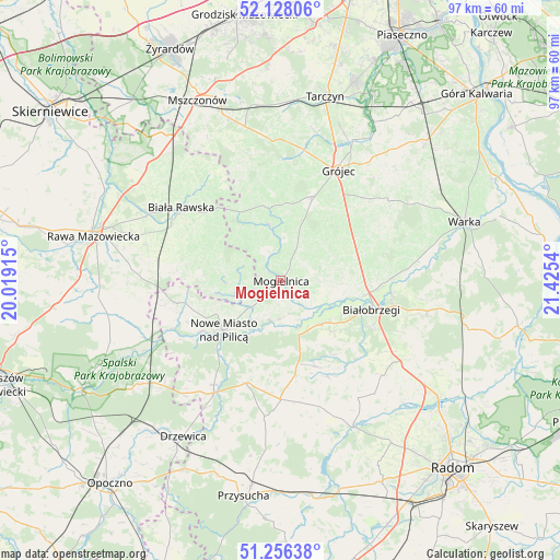
Mogielnica GPS coordinates[2]
51° 41' 39.552" North, 20° 43' 20.172" East
| Map corner | latitude | longitude |
|---|---|---|
| Upper-left | 52.12806°, | 20.01915° |
| Center: | 51.69432°, | 20.72227° |
| Lower-right: | 51.25638°, | 21.4254° |
| Map W x H: | 96.9×96.9 km | = 60.2×60.2mi |
| max Lat: | 54.83135° ⇑40% North |
| Mogielnica: | 51.69432° |
| min Lat: | ⇓60% South 49.21328° |
| min Long | Mogielnica | max Long |
| 14.20249° | 20.72227° | 24.03723° |
| W 68.1%⇐ | ⇒31.9% E |
Elevation
Elevation of Mogielnica is 135 m = 443 ft, and this is 56.4 m = 185 ft below average elevation for this country.
| Max E: |
974 m = 3196 ft | 64.4% |
| Avg. | 191.4 m = 628 ft | |
| Mogielnica | 135 m = 443 ft | |
Min E: |
-3 m = -10 ft | 35.6% |
See also: Poland elevation on elevation.city.
Geographical zone
Mogielnica is located in North temperate zone (between Tropic of Cancer and the Arctic Circle). Distance of this North polar circle is 1653.3 km =1027.3 mi to North.| Distance of | km | miles | from Mogielnica |
|---|---|---|---|
| North Pole | 4259.2 | 2646.5 | to North |
| Arctic Circle | 1653.3 | 1027.3 | to North |
| Tropic Cancer | 3142 | 1952.3 | to South |
| Equator | 5747.9 | 3571.6 | to South |


Nearby cities:
15 places around Mogielnica: (largest is in red/bold)
• Belsk Duży
15.8 km =9.8 mi,  22°
22°
• Białobrzegi
16.6 km =10.3 mi,  108°
108°
• Błędów
9.4 km =5.8 mi,  349°
349°
• Goszczyn
9.8 km =6.1 mi,  64°
64°
• Grójec
21.2 km =13.2 mi,  28°
28°
• Jasieniec
20.6 km =12.8 mi,  46°
46°
• Klwów
18.7 km =11.6 mi,  198°
198°
• Nowe Miasto nad Pilicą
13.2 km =8.2 mi,  229°
229°
• Potworów
20.6 km =12.8 mi,  180°
180°
• Promna
16.4 km =10.2 mi,  95°
95°
• Przybyszew
9.6 km =6 mi, 111°
• Radzanów
18.1 km =11.2 mi,  147°
147°
• Sadkowice
14.7 km =9.1 mi,  283°
283°
• Sucha
17.7 km =11 mi,  117°
117°
• Wyśmierzyce
10 km =6.2 mi,  140°
140°
Sources, notices
• [Note1] Compared only with cities in Poland existing in our database
• [Src1] Map data: © OpenStreetMap contributors (CC-BY-SA)
• [Src2] Other city data from geonames.org with taken over terms of usage.
• [Src3] Geographical zone / Annual Mean Temperature by Robert A. Rohde @ Wikipedia
