Błędów geodata
Błędów (Mazovia) is a populated place; located in Poland in Europe/Warsaw (GMT+2) time zone. With population of 1,098 people, there are 2359 cities with bigger population in this country. Compared to other cities in Poland, 61.6% of cities are located further ↓South; 67.6% of cities are located further ←West and 56% of cities have higher elevation than Błędów. Note1


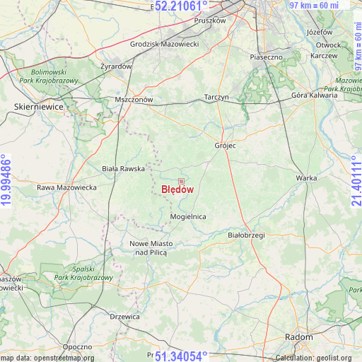
Błędów GPS coordinates[2]
51° 46' 39.612" North, 20° 41' 52.728" East
| Map corner | latitude | longitude |
|---|---|---|
| Upper-left | 52.21061°, | 19.99486° |
| Center: | 51.77767°, | 20.69798° |
| Lower-right: | 51.34054°, | 21.40111° |
| Map W x H: | 96.7×96.7 km | = 60.1×60.1mi |
| max Lat: | 54.83135° ⇑38.4% North |
| Błędów: | 51.77767° |
| min Lat: | ⇓61.6% South 49.21328° |
| min Long | Błędów | max Long |
| 14.20249° | 20.69798° | 24.03723° |
| W 67.6%⇐ | ⇒32.4% E |
Elevation
Elevation of Błędów is 156 m = 512 ft, and this is 35.4 m = 116 ft below average elevation for this country.
| Max E: |
974 m = 3196 ft | 56% |
| Avg. | 191.4 m = 628 ft | |
| Błędów | 156 m = 512 ft | |
Min E: |
-3 m = -10 ft | 44% |
See also: Poland elevation on elevation.city.
Geographical zone
Błędów is located in North temperate zone (between Tropic of Cancer and the Arctic Circle). Distance of this North polar circle is 1644 km =1021.5 mi to North.| Distance of | km | miles | from Błędów |
|---|---|---|---|
| North Pole | 4249.9 | 2640.8 | to North |
| Arctic Circle | 1644 | 1021.5 | to North |
| Tropic Cancer | 3151.2 | 1958.1 | to South |
| Equator | 5757.1 | 3577.3 | to South |


Nearby cities:
15 places around Błędów: (largest is in red/bold)
• Belsk Duży
9.3 km =5.8 mi,  54°
54°
• Biała Rawska
15.9 km =9.9 mi,  282°
282°
• Białobrzegi
22.7 km =14.1 mi,  129°
129°
• Goszczyn
11.7 km =7.3 mi,  115°
115°
• Grójec
15 km =9.3 mi, 51°
• Jasieniec
17.4 km =10.8 mi,  73°
73°
• Kowiesy
22.8 km =14.2 mi,  302°
302°
• Mogielnica
9.4 km =5.8 mi,  169°
169°
• Nowe Miasto nad Pilicą
19.6 km =12.2 mi,  205°
205°
• Pniewy
15.6 km =9.7 mi,  12°
12°
• Promna
21 km =13 mi, 121°
• Przybyszew
16.6 km =10.3 mi,  140°
140°
• Regnów
21.6 km =13.4 mi,  261°
261°
• Sadkowice
13.9 km =8.6 mi,  245°
245°
• Wyśmierzyce
18.8 km =11.7 mi,  154°
154°
Sources, notices
• [Note1] Compared only with cities in Poland existing in our database
• [Src1] Map data: © OpenStreetMap contributors (CC-BY-SA)
• [Src2] Other city data from geonames.org with taken over terms of usage.
• [Src3] Geographical zone / Annual Mean Temperature by Robert A. Rohde @ Wikipedia
