Isabela geodata
Isabela is a seat of a first-order administrative division; located in Puerto Rico in America/Puerto_Rico (GMT-4) time zone. With population of 12,505 people, there are 23 cities with bigger population in this country. Compared to other cities in Puerto Rico, 100% of cities are located further ↓South; 87.1% of cities are located further →East and 63.6% of cities have lower elevation than Isabela. Note1


Isabela GPS coordinates[2]
18° 30' 2.808" North, 67° 1' 27.66" West
| Map corner | latitude | longitude |
|---|---|---|
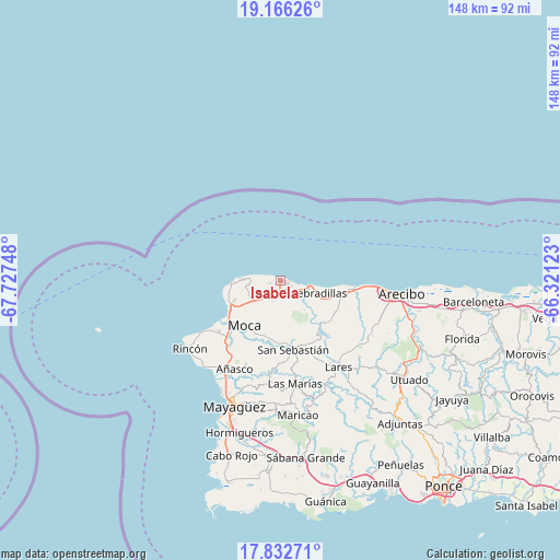
| Upper-left | 19.16626°, | -67.72748° |
| Center: | 18.50078°, | -67.02435° |
| Lower-right: | 17.83271°, | -66.32123° |
| Map W x H: | 148.3×148.3 km | = 92.1×92.1mi |
| max Lat: | 18.50078° ⇑0% North |
| Isabela: | 18.50078° |
| min Lat: | ⇓100% South 17.95358° |
| min Long | Isabela | max Long |
| -67.2499° | -67.02435° | -65.30099° |
| W 12.9%⇐ | ⇒87.1% E |
Elevation
Elevation of Isabela is 76 m = 249 ft, and this is 24.5 m = 80 ft below average elevation for this country.
| Max E: |
655 m = 2149 ft | 36.4% |
| Avg. | 100.5 m = 330 ft | |
| Isabela | 76 m = 249 ft | |
Min E: |
1 m = 3 ft | 63.6% |
See also: Puerto Rico elevation on elevation.city.
Geographical zone
Isabela is located in North Torrid zone (between Equator and Tropic of Cancer). Distance of this Northern Tropic circle is 548.8 km =341 mi to North.| Distance of | km | miles | from Isabela |
|---|---|---|---|
| North Pole | 7950 | 4939.9 | to North |
| Arctic Circle | 5344.1 | 3320.7 | to North |
| Tropic Cancer | 548.8 | 341 | to North |
| Equator | 2057.1 | 1278.2 | to South |


Nearby cities:
15 places around Isabela: (largest is in red/bold)
• Aceitunas
7.7 km =4.8 mi,  213°
213°
• Aguadilla
15.9 km =9.9 mi,  239°
239°
• Caban
13.4 km =8.3 mi, 241°
• Cacao
11.6 km =7.2 mi,  127°
127°
• Camuy
19 km =11.8 mi,  95°
95°
• Hato Arriba
16.2 km =10.1 mi,  183°
183°
• Luyando
20.7 km =12.9 mi,  222°
222°
• Moca
15.1 km =9.4 mi, 218°
• Mora
4.3 km =2.7 mi,  191°
191°
• Piedra Gorda
16.2 km =10.1 mi,  117°
117°
• Quebradillas
9.5 km =5.9 mi,  108°
108°
• Rafael Hernandez
6.6 km =4.1 mi, 240°
• San Antonio
7.9 km =4.9 mi,  263°
263°
• San Antonio
9.6 km =6 mi, 124°
• San Sebastián
18.6 km =11.6 mi,  168°
168°
Sources, notices
• [Note1] Compared only with cities in Puerto Rico existing in our database
• [Src1] Map data: © OpenStreetMap contributors (CC-BY-SA)
• [Src2] Other city data from geonames.org with taken over terms of usage.
• [Src3] Geographical zone / Annual Mean Temperature by Robert A. Rohde @ Wikipedia
