Candelero Arriba geodata
Candelero Arriba (Humacao) is a populated place; located in Puerto Rico in America/Puerto_Rico (GMT-4) time zone. With population of 1,346 people, there are 185 cities with bigger population in this country. Compared to other cities in Puerto Rico, 67.1% of cities are located further ↑North; 89.8% of cities are located further ←West and 61.8% of cities have lower elevation than Candelero Arriba. Note1


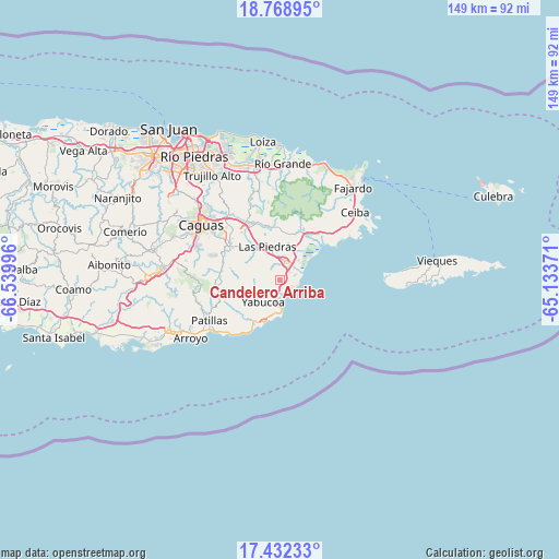
Candelero Arriba GPS coordinates[2]
18° 6' 6.876" North, 65° 50' 12.588" West
| Map corner | latitude | longitude |
|---|---|---|
| Upper-left | 18.76895°, | -66.53996° |
| Center: | 18.10191°, | -65.83683° |
| Lower-right: | 17.43233°, | -65.13371° |
| Map W x H: | 148.6×148.6 km | = 92.3×92.3mi |
| max Lat: | 18.50078° ⇑67.1% North |
| Candelero Arriba: | 18.10191° |
| min Lat: | ⇓32.9% South 17.95358° |
| min Long | Candelero Arrib | max Long |
| -67.2499° | -65.83683° | -65.30099° |
| W 89.8%⇐ | ⇒10.2% E |
Elevation
Elevation of Candelero Arriba is 73 m = 240 ft, and this is 27.5 m = 90 ft below average elevation for this country.
| Max E: |
655 m = 2149 ft | 38.2% |
| Avg. | 100.5 m = 330 ft | |
| Candelero Arriba | 73 m = 240 ft | |
Min E: |
1 m = 3 ft | 61.8% |
See also: Puerto Rico elevation on elevation.city.
Geographical zone
Candelero Arriba is located in North Torrid zone (between Equator and Tropic of Cancer). Distance of this Northern Tropic circle is 593.2 km =368.6 mi to North.| Distance of | km | miles | from Candelero Arriba |
|---|---|---|---|
| North Pole | 7994.3 | 4967.4 | to North |
| Arctic Circle | 5388.4 | 3348.2 | to North |
| Tropic Cancer | 593.2 | 368.6 | to North |
| Equator | 2012.7 | 1250.6 | to South |


Nearby cities:
15 places around Candelero Arriba: (largest is in red/bold)
• Antón Ruiz
9.7 km =6 mi,  17°
17°
• Bajandas
8.5 km =5.3 mi,  43°
43°
• Boqueron
11.8 km =7.3 mi,  354°
354°
• Comunas
1.8 km =1.1 mi,  204°
204°
• El Negro
7.3 km =4.5 mi,  192°
192°
• Emajagua
12.3 km =7.6 mi, 203°
• Humacao
5.4 km =3.4 mi,  10°
10°
• La Fermina
8.4 km =5.2 mi, 347°
• Las Piedras
9.5 km =5.9 mi,  340°
340°
• Martorell
7.1 km =4.4 mi,  246°
246°
• Maunabo
12.4 km =7.7 mi,  212°
212°
• Playita
9.8 km =6.1 mi,  229°
229°
• Punta Santiago
11.8 km =7.3 mi,  52°
52°
• Rosa Sanchez
9.3 km =5.8 mi,  241°
241°
• Yabucoa
7.3 km =4.5 mi,  218°
218°
Sources, notices
• [Note1] Compared only with cities in Puerto Rico existing in our database
• [Src1] Map data: © OpenStreetMap contributors (CC-BY-SA)
• [Src2] Other city data from geonames.org with taken over terms of usage.
• [Src3] Geographical zone / Annual Mean Temperature by Robert A. Rohde @ Wikipedia
