Humacao geodata
Humacao is a seat of a first-order administrative division; located in Puerto Rico in America/Puerto_Rico (GMT-4) time zone. With population of 20,387 people, there are 15 cities with bigger population in this country. Compared to other cities in Puerto Rico, 63.1% of cities are located further ↑North; 91.1% of cities are located further ←West and 67.1% of cities have higher elevation than Humacao. Note1


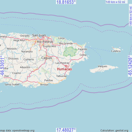
Humacao GPS coordinates[2]
18° 8' 58.848" North, 65° 49' 38.568" West
| Map corner | latitude | longitude |
|---|---|---|
| Upper-left | 18.81653°, | -66.53051° |
| Center: | 18.14968°, | -65.82738° |
| Lower-right: | 17.48027°, | -65.12426° |
| Map W x H: | 148.6×148.6 km | = 92.3×92.3mi |
| max Lat: | 18.50078° ⇑63.1% North |
| Humacao: | 18.14968° |
| min Lat: | ⇓36.9% South 17.95358° |
| min Long | Humacao | max Long |
| -67.2499° | -65.82738° | -65.30099° |
| W 91.1%⇐ | ⇒8.9% E |
Elevation
Elevation of Humacao is 25 m = 82 ft, and this is 75.5 m = 248 ft below average elevation for this country.
| Max E: |
655 m = 2149 ft | 67.1% |
| Avg. | 100.5 m = 330 ft | |
| Humacao | 25 m = 82 ft | |
Min E: |
1 m = 3 ft | 32.9% |
See also: Puerto Rico elevation on elevation.city.
Geographical zone
Humacao is located in North Torrid zone (between Equator and Tropic of Cancer). Distance of this Northern Tropic circle is 587.9 km =365.3 mi to North.| Distance of | km | miles | from Humacao |
|---|---|---|---|
| North Pole | 7989 | 4964.1 | to North |
| Arctic Circle | 5383.1 | 3344.9 | to North |
| Tropic Cancer | 587.9 | 365.3 | to North |
| Equator | 2018.1 | 1254 | to South |


Nearby cities:
15 places around Humacao: (largest is in red/bold)
• Antón Ruiz
4.4 km =2.7 mi,  26°
26°
• Bajandas
4.9 km =3 mi,  79°
79°
• Boqueron
6.8 km =4.2 mi,  340°
340°
• Candelero Arriba
5.4 km =3.4 mi,  190°
190°
• Comunas
7.2 km =4.5 mi, 193°
• El Mangó
10.9 km =6.8 mi,  329°
329°
• La Fermina
4 km =2.5 mi,  316°
316°
• Las Piedras
5.5 km =3.4 mi,  312°
312°
• Martorell
11.1 km =6.9 mi,  222°
222°
• Naguabo
12 km =7.5 mi,  54°
54°
• Peña Pobre
7.3 km =4.5 mi,  4°
4°
• Pueblito del Rio
9.5 km =5.9 mi, 336°
• Punta Santiago
8.6 km =5.3 mi, 77°
• Río Blanco
8.7 km =5.4 mi, 28°
• Yabucoa
12.3 km =7.6 mi,  206°
206°
Sources, notices
• [Note1] Compared only with cities in Puerto Rico existing in our database
• [Src1] Map data: © OpenStreetMap contributors (CC-BY-SA)
• [Src2] Other city data from geonames.org with taken over terms of usage.
• [Src3] Geographical zone / Annual Mean Temperature by Robert A. Rohde @ Wikipedia
