Brenas geodata
Brenas (Vega Alta) is a populated place; located in Puerto Rico in America/Puerto_Rico (GMT-4) time zone. With population of 2,104 people, there are 133 cities with bigger population in this country. Compared to other cities in Puerto Rico, 96.4% of cities are located further ↓South; 50.7% of cities are located further →East and 92.9% of cities have higher elevation than Brenas. Note1


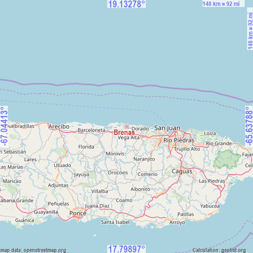
Brenas GPS coordinates[2]
18° 28' 1.812" North, 66° 20' 27.6" West
| Map corner | latitude | longitude |
|---|---|---|
| Upper-left | 19.13278°, | -67.04413° |
| Center: | 18.46717°, | -66.341° |
| Lower-right: | 17.79897°, | -65.63788° |
| Map W x H: | 148.3×148.3 km | = 92.1×92.1mi |
| max Lat: | 18.50078° ⇑3.6% North |
| Brenas: | 18.46717° |
| min Lat: | ⇓96.4% South 17.95358° |
| min Long | Brenas | max Long |
| -67.2499° | -66.341° | -65.30099° |
| W 49.3%⇐ | ⇒50.7% E |
Elevation
Elevation of Brenas is 7 m = 23 ft, and this is 93.5 m = 307 ft below average elevation for this country.
| Max E: |
655 m = 2149 ft | 92.9% |
| Avg. | 100.5 m = 330 ft | |
| Brenas | 7 m = 23 ft | |
Min E: |
1 m = 3 ft | 7.1% |
See also: Puerto Rico elevation on elevation.city.
Geographical zone
Brenas is located in North Torrid zone (between Equator and Tropic of Cancer). Distance of this Northern Tropic circle is 552.6 km =343.4 mi to North.| Distance of | km | miles | from Brenas |
|---|---|---|---|
| North Pole | 7953.7 | 4942.2 | to North |
| Arctic Circle | 5347.8 | 3323 | to North |
| Tropic Cancer | 552.6 | 343.4 | to North |
| Equator | 2053.4 | 1275.9 | to South |


Nearby cities:
15 places around Brenas: (largest is in red/bold)
• Campanilla
12.1 km =7.5 mi,  114°
114°
• Ceiba
2.5 km =1.6 mi,  203°
203°
• Coto Norte
11.2 km =7 mi,  248°
248°
• Dorado
7.8 km =4.8 mi,  96°
96°
• Ingenio
12.4 km =7.7 mi, 102°
• Miranda
10 km =6.2 mi,  206°
206°
• Monserrate
3.9 km =2.4 mi, 210°
• Río Lajas
11.2 km =7 mi,  136°
136°
• Sabana
2 km =1.2 mi, 248°
• San Antonio
4.5 km =2.8 mi,  116°
116°
• San José
11.8 km =7.3 mi,  130°
130°
• Toa Alta
13.1 km =8.1 mi, 131°
• Toa Baja
9 km =5.6 mi, 106°
• Vega Alta
6.2 km =3.9 mi,  170°
170°
• Vega Baja
5.5 km =3.4 mi,  242°
242°
Sources, notices
• [Note1] Compared only with cities in Puerto Rico existing in our database
• [Src1] Map data: © OpenStreetMap contributors (CC-BY-SA)
• [Src2] Other city data from geonames.org with taken over terms of usage.
• [Src3] Geographical zone / Annual Mean Temperature by Robert A. Rohde @ Wikipedia
