Sabana geodata
Sabana (Vega Baja) is a populated place; located in Puerto Rico in America/Puerto_Rico (GMT-4) time zone. With population of 1,946 people, there are 146 cities with bigger population in this country. Compared to other cities in Puerto Rico, 94.7% of cities are located further ↓South; 52.4% of cities are located further →East and 95.6% of cities have higher elevation than Sabana. Note1


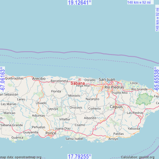
Sabana GPS coordinates[2]
18° 27' 38.808" North, 66° 21' 30.6" West
| Map corner | latitude | longitude |
|---|---|---|
| Upper-left | 19.12641°, | -67.06163° |
| Center: | 18.46078°, | -66.3585° |
| Lower-right: | 17.79255°, | -65.65538° |
| Map W x H: | 148.3×148.3 km | = 92.1×92.1mi |
| max Lat: | 18.50078° ⇑5.3% North |
| Sabana: | 18.46078° |
| min Lat: | ⇓94.7% South 17.95358° |
| min Long | Sabana | max Long |
| -67.2499° | -66.3585° | -65.30099° |
| W 47.6%⇐ | ⇒52.4% E |
Elevation
Elevation of Sabana is 5 m = 16 ft, and this is 95.5 m = 313 ft below average elevation for this country.
| Max E: |
655 m = 2149 ft | 95.6% |
| Avg. | 100.5 m = 330 ft | |
| Sabana | 5 m = 16 ft | |
Min E: |
1 m = 3 ft | 4.4% |
See also: Puerto Rico elevation on elevation.city.
Geographical zone
Sabana is located in North Torrid zone (between Equator and Tropic of Cancer). Distance of this Northern Tropic circle is 553.3 km =343.8 mi to North.| Distance of | km | miles | from Sabana |
|---|---|---|---|
| North Pole | 7954.4 | 4942.6 | to North |
| Arctic Circle | 5348.5 | 3323.4 | to North |
| Tropic Cancer | 553.3 | 343.8 | to North |
| Equator | 2052.6 | 1275.4 | to South |


Nearby cities:
15 places around Sabana: (largest is in red/bold)
• Brenas
2 km =1.2 mi,  68°
68°
• Campanilla
13.6 km =8.5 mi,  108°
108°
• Ceiba
1.8 km =1.1 mi,  152°
152°
• Corozal
14 km =8.7 mi,  161°
161°
• Coto Norte
9.2 km =5.7 mi,  248°
248°
• Dorado
9.6 km =6 mi,  91°
91°
• Miranda
8.7 km =5.4 mi,  197°
197°
• Monserrate
2.7 km =1.7 mi,  182°
182°
• Río Lajas
12.1 km =7.5 mi,  127°
127°
• San Antonio
6 km =3.7 mi,  102°
102°
• San José
12.9 km =8 mi,  122°
122°
• Tierras Nuevas Poniente
13.7 km =8.5 mi,  270°
270°
• Toa Baja
10.6 km =6.6 mi, 100°
• Vega Alta
6.1 km =3.8 mi, 152°
• Vega Baja
3.6 km =2.2 mi,  239°
239°
Sources, notices
• [Note1] Compared only with cities in Puerto Rico existing in our database
• [Src1] Map data: © OpenStreetMap contributors (CC-BY-SA)
• [Src2] Other city data from geonames.org with taken over terms of usage.
• [Src3] Geographical zone / Annual Mean Temperature by Robert A. Rohde @ Wikipedia
