Rafael Gonzalez geodata
Rafael Gonzalez (Hatillo) is a populated place; located in Puerto Rico in America/Puerto_Rico (GMT-4) time zone. With population of 2,325 people, there are 122 cities with bigger population in this country. Compared to other cities in Puerto Rico, 82.2% of cities are located further ↓South; 76.4% of cities are located further →East and 75.1% of cities have lower elevation than Rafael Gonzalez. Note1


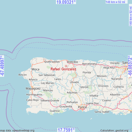
Rafael Gonzalez GPS coordinates[2]
18° 25' 38.82" North, 66° 47' 12.624" West
| Map corner | latitude | longitude |
|---|---|---|
| Upper-left | 19.09321°, | -67.48997° |
| Center: | 18.42745°, | -66.78684° |
| Lower-right: | 17.7591°, | -66.08372° |
| Map W x H: | 148.3×148.3 km | = 92.1×92.1mi |
| max Lat: | 18.50078° ⇑17.8% North |
| Rafael Gonzalez: | 18.42745° |
| min Lat: | ⇓82.2% South 17.95358° |
| min Long | Rafael Gonzalez | max Long |
| -67.2499° | -66.78684° | -65.30099° |
| W 23.6%⇐ | ⇒76.4% E |
Elevation
Elevation of Rafael Gonzalez is 130 m = 427 ft, and this is 29.5 m = 97 ft above average elevation for this country.
| Max E: |
655 m = 2149 ft | 24.9% |
| Rafael Gonzalez | 130 m 427 ft | |
| Avg. | 100.5 m = 330 ft | |
Min E: |
1 m = 3 ft | 75.1% |
See also: Puerto Rico elevation on elevation.city.
Geographical zone
Rafael Gonzalez is located in North Torrid zone (between Equator and Tropic of Cancer). Distance of this Northern Tropic circle is 557 km =346.1 mi to North.| Distance of | km | miles | from Rafael Gonzalez |
|---|---|---|---|
| North Pole | 7958.1 | 4944.9 | to North |
| Arctic Circle | 5352.2 | 3325.7 | to North |
| Tropic Cancer | 557 | 346.1 | to North |
| Equator | 2048.9 | 1273.1 | to South |


Nearby cities:
15 places around Rafael Gonzalez: (largest is in red/bold)
• Animas
16.2 km =10.1 mi,  82°
82°
• Arecibo
9 km =5.6 mi,  56°
56°
• Bajadero
10.9 km =6.8 mi,  90°
90°
• Cacao
15.9 km =9.9 mi,  273°
273°
• Camuy
8.8 km =5.5 mi,  315°
315°
• Carrizales
6.1 km =3.8 mi,  356°
356°
• Cayuco
16 km =9.9 mi,  161°
161°
• Corcovado
3.6 km =2.2 mi,  17°
17°
• Hatillo
7.7 km =4.8 mi,  328°
328°
• Lares
17.6 km =10.9 mi,  212°
212°
• Piedra Gorda
10.7 km =6.6 mi, 273°
• Quebrada
9.2 km =5.7 mi, 211°
• Quebradillas
16.8 km =10.4 mi,  287°
287°
• Rafael Capo
2.3 km =1.4 mi,  167°
167°
• San Antonio
17.4 km =10.8 mi,  278°
278°
Sources, notices
• [Note1] Compared only with cities in Puerto Rico existing in our database
• [Src1] Map data: © OpenStreetMap contributors (CC-BY-SA)
• [Src2] Other city data from geonames.org with taken over terms of usage.
• [Src3] Geographical zone / Annual Mean Temperature by Robert A. Rohde @ Wikipedia
