Piedra Gorda geodata
Piedra Gorda (Camuy) is a populated place; located in Puerto Rico in America/Puerto_Rico (GMT-4) time zone. With population of 1,927 people, there are 147 cities with bigger population in this country. Compared to other cities in Puerto Rico, 85.8% of cities are located further ↓South; 80.9% of cities are located further →East and 84% of cities have lower elevation than Piedra Gorda. Note1


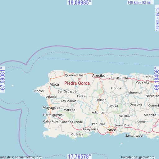
Piedra Gorda GPS coordinates[2]
18° 26' 2.796" North, 66° 53' 15.648" West
| Map corner | latitude | longitude |
|---|---|---|
| Upper-left | 19.09985°, | -67.59081° |
| Center: | 18.43411°, | -66.88768° |
| Lower-right: | 17.76578°, | -66.18456° |
| Map W x H: | 148.3×148.3 km | = 92.1×92.1mi |
| max Lat: | 18.50078° ⇑14.2% North |
| Piedra Gorda: | 18.43411° |
| min Lat: | ⇓85.8% South 17.95358° |
| min Long | Piedra Gorda | max Long |
| -67.2499° | -66.88768° | -65.30099° |
| W 19.1%⇐ | ⇒80.9% E |
Elevation
Elevation of Piedra Gorda is 180 m = 591 ft, and this is 79.5 m = 261 ft above average elevation for this country.
| Max E: |
655 m = 2149 ft | 16% |
| Piedra Gorda | 180 m 591 ft | |
| Avg. | 100.5 m = 330 ft | |
Min E: |
1 m = 3 ft | 84% |
See also: Puerto Rico elevation on elevation.city.
Geographical zone
Piedra Gorda is located in North Torrid zone (between Equator and Tropic of Cancer). Distance of this Northern Tropic circle is 556.2 km =345.6 mi to North.| Distance of | km | miles | from Piedra Gorda |
|---|---|---|---|
| North Pole | 7957.4 | 4944.5 | to North |
| Arctic Circle | 5351.5 | 3325.3 | to North |
| Tropic Cancer | 556.2 | 345.6 | to North |
| Equator | 2049.7 | 1273.6 | to South |


Nearby cities:
15 places around Piedra Gorda: (largest is in red/bold)
• Cacao
5.2 km =3.2 mi,  273°
273°
• Camuy
7.1 km =4.4 mi,  39°
39°
• Carrizales
11.6 km =7.2 mi,  62°
62°
• Corcovado
12.1 km =7.5 mi,  76°
76°
• Hatillo
8.8 km =5.5 mi,  48°
48°
• Isabela
16.2 km =10.1 mi,  297°
297°
• Juncal
13.8 km =8.6 mi,  193°
193°
• Lares
15.5 km =9.6 mi,  175°
175°
• Mora
15.6 km =9.7 mi,  281°
281°
• Quebrada
10.4 km =6.5 mi,  145°
145°
• Quebradillas
6.9 km =4.3 mi,  309°
309°
• Rafael Capo
11.5 km =7.1 mi,  105°
105°
• Rafael Gonzalez
10.7 km =6.6 mi,  93°
93°
• San Antonio
6.8 km =4.2 mi,  286°
286°
• San Sebastián
15.3 km =9.5 mi,  224°
224°
Sources, notices
• [Note1] Compared only with cities in Puerto Rico existing in our database
• [Src1] Map data: © OpenStreetMap contributors (CC-BY-SA)
• [Src2] Other city data from geonames.org with taken over terms of usage.
• [Src3] Geographical zone / Annual Mean Temperature by Robert A. Rohde @ Wikipedia
