Quebradillas geodata
Quebradillas is a seat of a first-order administrative division; located in Puerto Rico in America/Puerto_Rico (GMT-4) time zone. With population of 5,620 people, there are 65 cities with bigger population in this country. Compared to other cities in Puerto Rico, 97.8% of cities are located further ↓South; 84% of cities are located further →East and 74.2% of cities have lower elevation than Quebradillas. Note1


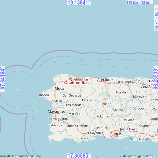
Quebradillas GPS coordinates[2]
18° 28' 25.788" North, 66° 56' 18.636" West
| Map corner | latitude | longitude |
|---|---|---|
| Upper-left | 19.13941°, | -67.64164° |
| Center: | 18.47383°, | -66.93851° |
| Lower-right: | 17.80565°, | -66.23539° |
| Map W x H: | 148.3×148.3 km | = 92.1×92.1mi |
| max Lat: | 18.50078° ⇑2.2% North |
| Quebradillas: | 18.47383° |
| min Lat: | ⇓97.8% South 17.95358° |
| min Long | Quebradillas | max Long |
| -67.2499° | -66.93851° | -65.30099° |
| W 16%⇐ | ⇒84% E |
Elevation
Elevation of Quebradillas is 119 m = 390 ft, and this is 18.5 m = 61 ft above average elevation for this country.
| Max E: |
655 m = 2149 ft | 25.8% |
| Quebradillas | 119 m 390 ft | |
| Avg. | 100.5 m = 330 ft | |
Min E: |
1 m = 3 ft | 74.2% |
See also: Puerto Rico elevation on elevation.city.
Geographical zone
Quebradillas is located in North Torrid zone (between Equator and Tropic of Cancer). Distance of this Northern Tropic circle is 551.8 km =342.9 mi to North.| Distance of | km | miles | from Quebradillas |
|---|---|---|---|
| North Pole | 7953 | 4941.8 | to North |
| Arctic Circle | 5347.1 | 3322.5 | to North |
| Tropic Cancer | 551.8 | 342.9 | to North |
| Equator | 2054.1 | 1276.4 | to South |


Nearby cities:
15 places around Quebradillas: (largest is in red/bold)
• Aceitunas
13.8 km =8.6 mi,  255°
255°
• Cacao
4.1 km =2.5 mi,  177°
177°
• Camuy
9.9 km =6.2 mi,  83°
83°
• Carrizales
15.7 km =9.8 mi,  86°
86°
• Corcovado
17.2 km =10.7 mi,  95°
95°
• Hatillo
12 km =7.5 mi, 83°
• Hato Arriba
16.6 km =10.3 mi,  217°
217°
• Isabela
9.5 km =5.9 mi,  288°
288°
• Mora
10 km =6.2 mi, 263°
• Piedra Gorda
6.9 km =4.3 mi,  129°
129°
• Rafael Gonzalez
16.8 km =10.4 mi,  107°
107°
• Rafael Hernandez
14.8 km =9.2 mi,  268°
268°
• San Antonio
2.7 km =1.7 mi,  205°
205°
• San Antonio
17 km =10.6 mi,  276°
276°
• San Sebastián
16.2 km =10.1 mi,  199°
199°
Sources, notices
• [Note1] Compared only with cities in Puerto Rico existing in our database
• [Src1] Map data: © OpenStreetMap contributors (CC-BY-SA)
• [Src2] Other city data from geonames.org with taken over terms of usage.
• [Src3] Geographical zone / Annual Mean Temperature by Robert A. Rohde @ Wikipedia
