San Antonio geodata
San Antonio (Quebradillas) is a populated place; located in Puerto Rico in America/Puerto_Rico (GMT-4) time zone. With population of 1,203 people, there are 197 cities with bigger population in this country. Compared to other cities in Puerto Rico, 92.9% of cities are located further ↓South; 84.9% of cities are located further →East and 81.8% of cities have lower elevation than San Antonio. Note1


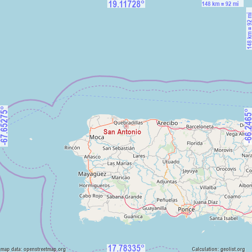
San Antonio GPS coordinates[2]
18° 27' 5.796" North, 66° 56' 58.632" West
| Map corner | latitude | longitude |
|---|---|---|
| Upper-left | 19.11728°, | -67.65275° |
| Center: | 18.45161°, | -66.94962° |
| Lower-right: | 17.78335°, | -66.2465° |
| Map W x H: | 148.3×148.3 km | = 92.1×92.1mi |
| max Lat: | 18.50078° ⇑7.1% North |
| San Antonio: | 18.45161° |
| min Lat: | ⇓92.9% South 17.95358° |
| min Long | San Antonio | max Long |
| -67.2499° | -66.94962° | -65.30099° |
| W 15.1%⇐ | ⇒84.9% E |
Elevation
Elevation of San Antonio is 164 m = 538 ft, and this is 63.5 m = 208 ft above average elevation for this country.
| Max E: |
655 m = 2149 ft | 18.2% |
| San Antonio | 164 m 538 ft | |
| Avg. | 100.5 m = 330 ft | |
Min E: |
1 m = 3 ft | 81.8% |
See also: Puerto Rico elevation on elevation.city.
Geographical zone
San Antonio is located in North Torrid zone (between Equator and Tropic of Cancer). Distance of this Northern Tropic circle is 554.3 km =344.4 mi to North.| Distance of | km | miles | from San Antonio |
|---|---|---|---|
| North Pole | 7955.4 | 4943.3 | to North |
| Arctic Circle | 5349.5 | 3324 | to North |
| Tropic Cancer | 554.3 | 344.4 | to North |
| Equator | 2051.6 | 1274.8 | to South |


Nearby cities:
15 places around San Antonio: (largest is in red/bold)
• Aceitunas
12.2 km =7.6 mi,  265°
265°
• Cacao
2.1 km =1.3 mi,  141°
141°
• Camuy
11.6 km =7.2 mi,  72°
72°
• Carrizales
17.2 km =10.7 mi,  78°
78°
• Hatillo
13.7 km =8.5 mi, 73°
• Hato Arriba
13.9 km =8.6 mi,  219°
219°
• Isabela
9.6 km =6 mi,  304°
304°
• Juncal
15.7 km =9.8 mi,  168°
168°
• Mora
8.9 km =5.5 mi,  278°
278°
• Piedra Gorda
6.8 km =4.2 mi,  106°
106°
• Quebrada
16.3 km =10.1 mi,  130°
130°
• Quebradillas
2.7 km =1.7 mi,  25°
25°
• Rafael Hernandez
13.8 km =8.6 mi, 279°
• San Antonio
16.3 km =10.1 mi,  286°
286°
• San Sebastián
13.5 km =8.4 mi,  198°
198°
Sources, notices
• [Note1] Compared only with cities in Puerto Rico existing in our database
• [Src1] Map data: © OpenStreetMap contributors (CC-BY-SA)
• [Src2] Other city data from geonames.org with taken over terms of usage.
• [Src3] Geographical zone / Annual Mean Temperature by Robert A. Rohde @ Wikipedia
