Juncal geodata
Juncal (San Sebastián) is a populated place; located in Puerto Rico in America/Puerto_Rico (GMT-4) time zone. With population of 1,155 people, there are 202 cities with bigger population in this country. Compared to other cities in Puerto Rico, 59.1% of cities are located further ↓South; 83.1% of cities are located further →East and 92% of cities have lower elevation than Juncal. Note1


Juncal GPS coordinates[2]
18° 18' 49.824" North, 66° 55' 8.652" West
| Map corner | latitude | longitude |
|---|---|---|
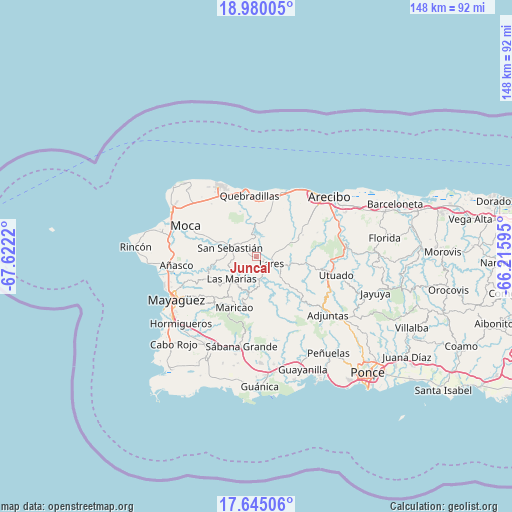
| Upper-left | 18.98005°, | -67.6222° |
| Center: | 18.31384°, | -66.91907° |
| Lower-right: | 17.64506°, | -66.21595° |
| Map W x H: | 148.4×148.4 km | = 92.2×92.2mi |
| max Lat: | 18.50078° ⇑40.9% North |
| Juncal: | 18.31384° |
| min Lat: | ⇓59.1% South 17.95358° |
| min Long | Juncal | max Long |
| -67.2499° | -66.91907° | -65.30099° |
| W 16.9%⇐ | ⇒83.1% E |
Elevation
Elevation of Juncal is 359 m = 1178 ft, and this is 258.5 m = 848 ft above average elevation for this country.
| Max E: |
655 m = 2149 ft | 8% |
| Juncal | 359 m 1178 ft | |
| Avg. | 100.5 m = 330 ft | |
Min E: |
1 m = 3 ft | 92% |
See also: Puerto Rico elevation on elevation.city.
Geographical zone
Juncal is located in North Torrid zone (between Equator and Tropic of Cancer). Distance of this Northern Tropic circle is 569.6 km =353.9 mi to North.| Distance of | km | miles | from Juncal |
|---|---|---|---|
| North Pole | 7970.8 | 4952.8 | to North |
| Arctic Circle | 5364.9 | 3333.6 | to North |
| Tropic Cancer | 569.6 | 353.9 | to North |
| Equator | 2036.3 | 1265.3 | to South |


Nearby cities:
15 places around Juncal: (largest is in red/bold)
• Cacao
13.8 km =8.6 mi,  352°
352°
• Camuy
20.5 km =12.7 mi,  22°
22°
• Cayuco
19.1 km =11.9 mi,  97°
97°
• Hato Arriba
13 km =8.1 mi,  291°
291°
• Lares
4.9 km =3 mi,  115°
115°
• Las Marías
10.3 km =6.4 mi,  228°
228°
• Maricao
16.1 km =10 mi,  203°
203°
• Mora
20.5 km =12.7 mi,  324°
324°
• Piedra Gorda
13.8 km =8.6 mi,  13°
13°
• Quebrada
10.3 km =6.4 mi,  62°
62°
• Quebradillas
17.9 km =11.1 mi, 353°
• Rafael Capo
17.8 km =11.1 mi,  54°
54°
• Rafael Gonzalez
18.8 km =11.7 mi, 47°
• San Antonio
15.7 km =9.8 mi, 348°
• San Sebastián
7.9 km =4.9 mi, 288°
Sources, notices
• [Note1] Compared only with cities in Puerto Rico existing in our database
• [Src1] Map data: © OpenStreetMap contributors (CC-BY-SA)
• [Src2] Other city data from geonames.org with taken over terms of usage.
• [Src3] Geographical zone / Annual Mean Temperature by Robert A. Rohde @ Wikipedia
