Vimeiro geodata
Vimeiro (Lisbon) is a populated place; located in Portugal in Europe/Lisbon (GMT+1) time zone. With population of 1,470 people, there are 693 cities with bigger population in this country. Compared to other cities in Portugal, 60.5% of cities are located further ↑North; 86.7% of cities are located further →East and 80.9% of cities have higher elevation than Vimeiro. Note1


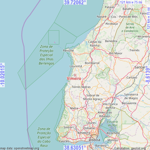
Vimeiro GPS coordinates[2]
39° 10' 39.648" North, 9° 19' 1.272" West
| Map corner | latitude | longitude |
|---|---|---|
| Upper-left | 39.72062°, | -10.02015° |
| Center: | 39.17768°, | -9.31702° |
| Lower-right: | 38.63051°, | -8.6139° |
| Map W x H: | 121.2×121.2 km | = 75.3×75.3mi |
| max Lat: | 42.11337° ⇑60.5% North |
| Vimeiro: | 39.17768° |
| min Lat: | ⇓39.5% South 32.6448° |
| min Long | Vimeiro | max Long |
| -31.17847° | -9.31702° | -6.27308° |
| W 13.3%⇐ | ⇒86.7% E |
Elevation
Elevation of Vimeiro is 32 m = 105 ft, and this is 145 m = 476 ft below average elevation for this country.
| Max E: |
1008 m = 3307 ft | 80.9% |
| Avg. | 177 m = 581 ft | |
| Vimeiro | 32 m = 105 ft | |
Min E: |
-128 m = -420 ft | 19.1% |
See also: Portugal elevation on elevation.city.
Geographical zone
Vimeiro is located in North temperate zone (between Tropic of Cancer and the Arctic Circle). Distance of this Northern Tropic circle is 1750.2 km =1087.5 mi to South.| Distance of | km | miles | from Vimeiro |
|---|---|---|---|
| North Pole | 5650.9 | 3511.3 | to North |
| Arctic Circle | 3045 | 1892.1 | to North |
| Tropic Cancer | 1750.2 | 1087.5 | to South |
| Equator | 4356.1 | 2706.8 | to South |


Nearby cities:
15 places around Vimeiro: (largest is in red/bold)
• A dos Cunhados
3.3 km =2.1 mi,  148°
148°
• Atouguia da Baleia
17.9 km =11.1 mi,  357°
357°
• Bombarral
16.9 km =10.5 mi,  53°
53°
• Cadaval
19.8 km =12.3 mi,  68°
68°
• Campelos
7.4 km =4.6 mi, 73°
• Ferrel
20.7 km =12.9 mi,  0°
0°
• Lourinhã
7.1 km =4.4 mi, 3°
• Moita dos Ferreiros
11.2 km =7 mi, 45°
• Peniche
20.6 km =12.8 mi,  344°
344°
• Serra de El-Rei
17.8 km =11.1 mi,  13°
13°
• Silveira
8.4 km =5.2 mi,  208°
208°
• São Bartolomeu
11.3 km =7 mi,  16°
16°
• São Pedro da Cadeira
12.9 km =8 mi,  201°
201°
• Torres Vedras
10.9 km =6.8 mi, 152°
• Vila Verde
17.6 km =10.9 mi,  98°
98°
Sources, notices
• [Note1] Compared only with cities in Portugal existing in our database
• [Src1] Map data: © OpenStreetMap contributors (CC-BY-SA)
• [Src2] Other city data from geonames.org with taken over terms of usage.
• [Src3] Geographical zone / Annual Mean Temperature by Robert A. Rohde @ Wikipedia
