A dos Cunhados geodata
A dos Cunhados (Lisbon) is a populated place; located in Portugal in Europe/Lisbon (GMT+1) time zone. With population of 6,594 people, there are 334 cities with bigger population in this country. Compared to other cities in Portugal, 61.2% of cities are located further ↑North; 86% of cities are located further →East and 80.9% of cities have higher elevation than A dos Cunhados. Note1


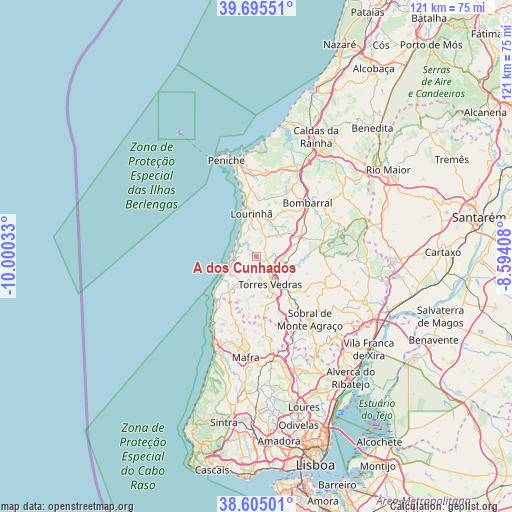
A dos Cunhados GPS coordinates[2]
39° 9' 8.532" North, 9° 17' 49.92" West
| Map corner | latitude | longitude |
|---|---|---|
| Upper-left | 39.69551°, | -10.00033° |
| Center: | 39.15237°, | -9.2972° |
| Lower-right: | 38.60501°, | -8.59408° |
| Map W x H: | 121.3×121.3 km | = 75.4×75.4mi |
| max Lat: | 42.11337° ⇑61.2% North |
| A dos Cunhados: | 39.15237° |
| min Lat: | ⇓38.8% South 32.6448° |
| min Long | A dos Cunhados | max Long |
| -31.17847° | -9.2972° | -6.27308° |
| W 14%⇐ | ⇒86% E |
Elevation
Elevation of A dos Cunhados is 32 m = 105 ft, and this is 145 m = 476 ft below average elevation for this country.
| Max E: |
1008 m = 3307 ft | 80.9% |
| Avg. | 177 m = 581 ft | |
| A dos Cunhados | 32 m = 105 ft | |
Min E: |
-128 m = -420 ft | 19.1% |
See also: Portugal elevation on elevation.city.
Geographical zone
A dos Cunhados is located in North temperate zone (between Tropic of Cancer and the Arctic Circle). Distance of this Northern Tropic circle is 1747.4 km =1085.8 mi to South.| Distance of | km | miles | from A dos Cunhados |
|---|---|---|---|
| North Pole | 5653.7 | 3513 | to North |
| Arctic Circle | 3047.8 | 1893.8 | to North |
| Tropic Cancer | 1747.4 | 1085.8 | to South |
| Equator | 4353.3 | 2705 | to South |


Nearby cities:
15 places around A dos Cunhados: (largest is in red/bold)
• Bombarral
17.5 km =10.9 mi,  43°
43°
• Cabanas de Torres
19.9 km =12.4 mi,  88°
88°
• Cadaval
19.5 km =12.1 mi,  58°
58°
• Campelos
7.3 km =4.5 mi,  47°
47°
• Lourinhã
10 km =6.2 mi,  352°
352°
• Moita dos Ferreiros
12.4 km =7.7 mi,  30°
30°
• Santo Isidoro
19.5 km =12.1 mi,  206°
206°
• Silveira
7.4 km =4.6 mi,  231°
231°
• Sobral de Monte Agraço
19.4 km =12.1 mi,  139°
139°
• São Bartolomeu
13.7 km =8.5 mi,  6°
6°
• São Pedro da Cadeira
11.2 km =7 mi,  215°
215°
• Torres Vedras
7.6 km =4.7 mi,  153°
153°
• Ventosa
18.6 km =11.6 mi,  98°
98°
• Vila Verde
15.7 km =9.8 mi, 88°
• Vimeiro
3.3 km =2.1 mi,  328°
328°
Sources, notices
• [Note1] Compared only with cities in Portugal existing in our database
• [Src1] Map data: © OpenStreetMap contributors (CC-BY-SA)
• [Src2] Other city data from geonames.org with taken over terms of usage.
• [Src3] Geographical zone / Annual Mean Temperature by Robert A. Rohde @ Wikipedia
