Silveira geodata
Silveira (Lisbon) is a populated place; located in Portugal in Europe/Lisbon (GMT+1) time zone. With population of 6,942 people, there are 323 cities with bigger population in this country. Compared to other cities in Portugal, 62.1% of cities are located further ↑North; 87.8% of cities are located further →East and 76.9% of cities have higher elevation than Silveira. Note1


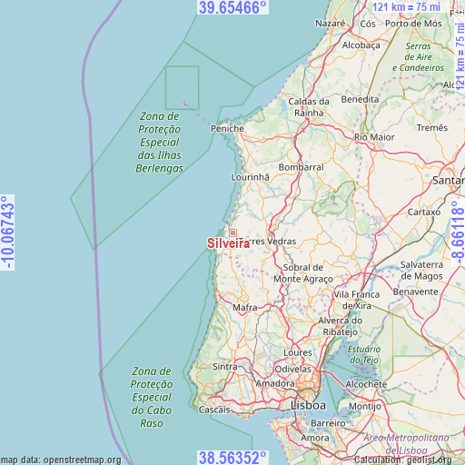
Silveira GPS coordinates[2]
39° 6' 40.32" North, 9° 21' 51.48" West
| Map corner | latitude | longitude |
|---|---|---|
| Upper-left | 39.65466°, | -10.06743° |
| Center: | 39.1112°, | -9.3643° |
| Lower-right: | 38.56352°, | -8.66118° |
| Map W x H: | 121.3×121.3 km | = 75.4×75.4mi |
| max Lat: | 42.11337° ⇑62.1% North |
| Silveira: | 39.1112° |
| min Lat: | ⇓37.9% South 32.6448° |
| min Long | Silveira | max Long |
| -31.17847° | -9.3643° | -6.27308° |
| W 12.2%⇐ | ⇒87.8% E |
Elevation
Elevation of Silveira is 37 m = 121 ft, and this is 140 m = 459 ft below average elevation for this country.
| Max E: |
1008 m = 3307 ft | 76.9% |
| Avg. | 177 m = 581 ft | |
| Silveira | 37 m = 121 ft | |
Min E: |
-128 m = -420 ft | 23.1% |
See also: Portugal elevation on elevation.city.
Geographical zone
Silveira is located in North temperate zone (between Tropic of Cancer and the Arctic Circle). Distance of this Northern Tropic circle is 1742.8 km =1082.9 mi to South.| Distance of | km | miles | from Silveira |
|---|---|---|---|
| North Pole | 5658.3 | 3515.9 | to North |
| Arctic Circle | 3052.4 | 1896.7 | to North |
| Tropic Cancer | 1742.8 | 1082.9 | to South |
| Equator | 4348.8 | 2702.2 | to South |


Nearby cities:
15 places around Silveira: (largest is in red/bold)
• A dos Cunhados
7.4 km =4.6 mi,  51°
51°
• Campelos
14.6 km =9.1 mi, 49°
• Ericeira
17.1 km =10.6 mi,  195°
195°
• Lourinhã
15.2 km =9.4 mi,  17°
17°
• Mafra
19.5 km =12.1 mi,  170°
170°
• Malveira
21.9 km =13.6 mi,  155°
155°
• Moita dos Ferreiros
19.5 km =12.1 mi,  38°
38°
• Pereiro da Palhacana
23.1 km =14.4 mi,  109°
109°
• Santo Isidoro
13.2 km =8.2 mi,  193°
193°
• Sobral de Monte Agraço
21.1 km =13.1 mi,  118°
118°
• São Bartolomeu
19.7 km =12.2 mi, 22°
• São Pedro da Cadeira
4.6 km =2.9 mi, 187°
• Torres Vedras
9.4 km =5.8 mi,  103°
103°
• Vila Verde
22 km =13.7 mi,  77°
77°
• Vimeiro
8.4 km =5.2 mi,  28°
28°
Sources, notices
• [Note1] Compared only with cities in Portugal existing in our database
• [Src1] Map data: © OpenStreetMap contributors (CC-BY-SA)
• [Src2] Other city data from geonames.org with taken over terms of usage.
• [Src3] Geographical zone / Annual Mean Temperature by Robert A. Rohde @ Wikipedia
