São Pedro da Cadeira geodata
São Pedro da Cadeira (Lisbon) is a populated place; located in Portugal in Europe/Lisbon (GMT+1) time zone. With population of 4,452 people, there are 476 cities with bigger population in this country. Compared to other cities in Portugal, 62.8% of cities are located further ↑North; 87.9% of cities are located further →East and 65.2% of cities have higher elevation than São Pedro da Cadeira. Note1
Current local time in São Pedro da Cadeira:
10:44 PM, WednesdayDifference from your time zone: hours


São Pedro da Cadeira GPS coordinates[2]
39° 4' 11.388" North, 9° 22' 18.264" West
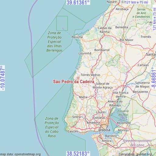
| Map corner | latitude | longitude |
|---|---|---|
| Upper-left | 39.61361°, | -10.07487° |
| Center: | 39.06983°, | -9.37174° |
| Lower-right: | 38.52183°, | -8.66861° |
| Map W x H: | 121.4×121.4 km | = 75.4×75.4mi |
| max Lat: | 42.11337° ⇑62.8% North |
| São Pedro da Cadeira: | 39.06983° |
| min Lat: | ⇓37.2% South 32.6448° |
| min Long | São Pedro da C | max Long |
| -31.17847° | -9.37174° | -6.27308° |
| W 12.1%⇐ | ⇒87.9% E |
Elevation
Elevation of São Pedro da Cadeira is 61 m = 200 ft, and this is 116 m = 381 ft below average elevation for this country.
| Max E: |
1008 m = 3307 ft | 65.2% |
| Avg. | 177 m = 581 ft | |
| São Pedro da Cadeira | 61 m = 200 ft | |
Min E: |
-128 m = -420 ft | 34.8% |
See also: Portugal elevation on elevation.city.
Geographical zone
São Pedro da Cadeira is located in North temperate zone (between Tropic of Cancer and the Arctic Circle). Distance of this Northern Tropic circle is 1738.2 km =1080.1 mi to South.| Distance of | km | miles | from São Pedro da Cadeira |
|---|---|---|---|
| North Pole | 5662.9 | 3518.8 | to North |
| Arctic Circle | 3057 | 1899.5 | to North |
| Tropic Cancer | 1738.2 | 1080.1 | to South |
| Equator | 4344.2 | 2699.4 | to South |


Nearby cities:
15 places around São Pedro da Cadeira: (largest is in red/bold)
• A dos Cunhados
11.2 km =7 mi,  35°
35°
• Campelos
18.4 km =11.4 mi, 39°
• Ericeira
12.5 km =7.8 mi,  197°
197°
• Lourinhã
19.8 km =12.3 mi,  14°
14°
• Mafra
15.2 km =9.4 mi,  165°
165°
• Malveira
18.2 km =11.3 mi,  147°
147°
• Milharado
20.2 km =12.6 mi,  132°
132°
• Pereiro da Palhacana
22.7 km =14.1 mi,  97°
97°
• Santo Isidoro
8.6 km =5.3 mi, 196°
• Silveira
4.6 km =2.9 mi, 7°
• Sobral de Monte Agraço
19.9 km =12.4 mi,  106°
106°
• São João das Lampas
21.9 km =13.6 mi,  186°
186°
• Torres Vedras
10 km =6.2 mi,  76°
76°
• Venda do Pinheiro
20.3 km =12.6 mi,  143°
143°
• Vimeiro
12.9 km =8 mi,  21°
21°
Sources, notices
• [Note1] Compared only with cities in Portugal existing in our database
• [Src1] Map data: © OpenStreetMap contributors (CC-BY-SA)
• [Src2] Other city data from geonames.org with taken over terms of usage.
• [Src3] Geographical zone / Annual Mean Temperature by Robert A. Rohde @ Wikipedia
