Malveira geodata
Malveira (Lisbon) is a populated place; located in Portugal in Europe/Lisbon (GMT+1) time zone. With population of 4,747 people, there are 448 cities with bigger population in this country. Compared to other cities in Portugal, 66% of cities are located further ↑North; 84.6% of cities are located further →East and 77% of cities have lower elevation than Malveira. Note1


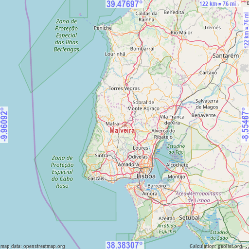
Malveira GPS coordinates[2]
38° 55' 55.668" North, 9° 15' 28.044" West
| Map corner | latitude | longitude |
|---|---|---|
| Upper-left | 39.47697°, | -9.96092° |
| Center: | 38.93213°, | -9.25779° |
| Lower-right: | 38.38307°, | -8.55467° |
| Map W x H: | 121.6×121.6 km | = 75.6×75.6mi |
| max Lat: | 42.11337° ⇑66% North |
| Malveira: | 38.93213° |
| min Lat: | ⇓34% South 32.6448° |
| min Long | Malveira | max Long |
| -31.17847° | -9.25779° | -6.27308° |
| W 15.4%⇐ | ⇒84.6% E |
Elevation
Elevation of Malveira is 253 m = 830 ft, and this is 76 m = 249 ft above average elevation for this country.
| Max E: |
1008 m = 3307 ft | 23% |
| Malveira | 253 m 830 ft | |
| Avg. | 177 m = 581 ft | |
Min E: |
-128 m = -420 ft | 77% |
See also: Portugal elevation on elevation.city.
Geographical zone
Malveira is located in North temperate zone (between Tropic of Cancer and the Arctic Circle). Distance of this Northern Tropic circle is 1722.9 km =1070.6 mi to South.| Distance of | km | miles | from Malveira |
|---|---|---|---|
| North Pole | 5678.2 | 3528.3 | to North |
| Arctic Circle | 3072.3 | 1909 | to North |
| Tropic Cancer | 1722.9 | 1070.6 | to South |
| Equator | 4328.8 | 2689.8 | to South |


Nearby cities:
15 places around Malveira: (largest is in red/bold)
• Almargem
9.8 km =6.1 mi,  187°
187°
• Arranhó
10.9 km =6.8 mi,  77°
77°
• Bucelas
12.5 km =7.8 mi,  105°
105°
• Caneças
13.5 km =8.4 mi,  168°
168°
• Ericeira
14.1 km =8.8 mi,  284°
284°
• Loures
13.7 km =8.5 mi,  145°
145°
• Mafra
6.1 km =3.8 mi, 276°
• Milharado
5.3 km =3.3 mi,  71°
71°
• Pero Pinheiro
10 km =6.2 mi,  214°
214°
• Ramada
15.5 km =9.6 mi,  156°
156°
• Santo Antão do Tojal
13.6 km =8.5 mi,  131°
131°
• Santo Isidoro
14.1 km =8.8 mi,  300°
300°
• Sobral de Monte Agraço
13.4 km =8.3 mi,  43°
43°
• São João das Lampas
13.8 km =8.6 mi,  241°
241°
• Venda do Pinheiro
2.4 km =1.5 mi, 112°
Sources, notices
• [Note1] Compared only with cities in Portugal existing in our database
• [Src1] Map data: © OpenStreetMap contributors (CC-BY-SA)
• [Src2] Other city data from geonames.org with taken over terms of usage.
• [Src3] Geographical zone / Annual Mean Temperature by Robert A. Rohde @ Wikipedia
