Santo Isidoro geodata
Santo Isidoro (Lisbon) is a populated place; located in Portugal in Europe/Lisbon (GMT+1) time zone. With population of 3,814 people, there are 538 cities with bigger population in this country. Compared to other cities in Portugal, 64.5% of cities are located further ↑North; 88.5% of cities are located further →East and 61.8% of cities have higher elevation than Santo Isidoro. Note1


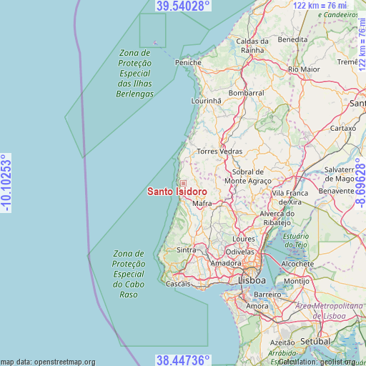
Santo Isidoro GPS coordinates[2]
38° 59' 45.348" North, 9° 23' 57.84" West
| Map corner | latitude | longitude |
|---|---|---|
| Upper-left | 39.54028°, | -10.10253° |
| Center: | 38.99593°, | -9.3994° |
| Lower-right: | 38.44736°, | -8.69628° |
| Map W x H: | 121.5×121.5 km | = 75.5×75.5mi |
| max Lat: | 42.11337° ⇑64.5% North |
| Santo Isidoro: | 38.99593° |
| min Lat: | ⇓35.5% South 32.6448° |
| min Long | Santo Isidoro | max Long |
| -31.17847° | -9.3994° | -6.27308° |
| W 11.5%⇐ | ⇒88.5% E |
Elevation
Elevation of Santo Isidoro is 73 m = 240 ft, and this is 104 m = 341 ft below average elevation for this country.
| Max E: |
1008 m = 3307 ft | 61.8% |
| Avg. | 177 m = 581 ft | |
| Santo Isidoro | 73 m = 240 ft | |
Min E: |
-128 m = -420 ft | 38.2% |
See also: Portugal elevation on elevation.city.
Geographical zone
Santo Isidoro is located in North temperate zone (between Tropic of Cancer and the Arctic Circle). Distance of this Northern Tropic circle is 1730 km =1075 mi to South.| Distance of | km | miles | from Santo Isidoro |
|---|---|---|---|
| North Pole | 5671.1 | 3523.9 | to North |
| Arctic Circle | 3065.2 | 1904.6 | to North |
| Tropic Cancer | 1730 | 1075 | to South |
| Equator | 4335.9 | 2694.2 | to South |


Nearby cities:
15 places around Santo Isidoro: (largest is in red/bold)
• A dos Cunhados
19.5 km =12.1 mi,  26°
26°
• Almargem
20 km =12.4 mi,  146°
146°
• Azenhas do Mar
17.9 km =11.1 mi,  196°
196°
• Ericeira
3.9 km =2.4 mi, 200°
• Fontanelas
16.8 km =10.4 mi,  191°
191°
• Mafra
9 km =5.6 mi,  136°
136°
• Malveira
14.1 km =8.8 mi,  120°
120°
• Milharado
18.1 km =11.2 mi,  107°
107°
• Pero Pinheiro
16.7 km =10.4 mi,  156°
156°
• Silveira
13.2 km =8.2 mi,  13°
13°
• São João das Lampas
13.6 km =8.5 mi,  179°
179°
• São Pedro da Cadeira
8.6 km =5.3 mi,  16°
16°
• Torres Vedras
16.1 km =10 mi,  48°
48°
• Venda do Pinheiro
16.6 km =10.3 mi, 119°
• Vimeiro
21.4 km =13.3 mi, 19°
Sources, notices
• [Note1] Compared only with cities in Portugal existing in our database
• [Src1] Map data: © OpenStreetMap contributors (CC-BY-SA)
• [Src2] Other city data from geonames.org with taken over terms of usage.
• [Src3] Geographical zone / Annual Mean Temperature by Robert A. Rohde @ Wikipedia
