Mafra geodata
Mafra (Lisbon) is a seat of a second-order administrative division; located in Portugal in Europe/Lisbon (GMT+1) time zone. With population of 12,259 people, there are 166 cities with bigger population in this country. Compared to other cities in Portugal, 65.7% of cities are located further ↑North; 87.1% of cities are located further →East and 74.1% of cities have lower elevation than Mafra. Note1


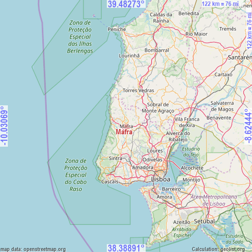
Mafra GPS coordinates[2]
38° 56' 16.548" North, 9° 19' 39.216" West
| Map corner | latitude | longitude |
|---|---|---|
| Upper-left | 39.48273°, | -10.03069° |
| Center: | 38.93793°, | -9.32756° |
| Lower-right: | 38.38891°, | -8.62444° |
| Map W x H: | 121.6×121.6 km | = 75.6×75.6mi |
| max Lat: | 42.11337° ⇑65.7% North |
| Mafra: | 38.93793° |
| min Lat: | ⇓34.3% South 32.6448° |
| min Long | Mafra | max Long |
| -31.17847° | -9.32756° | -6.27308° |
| W 12.9%⇐ | ⇒87.1% E |
Elevation
Elevation of Mafra is 230 m = 755 ft, and this is 53 m = 174 ft above average elevation for this country.
| Max E: |
1008 m = 3307 ft | 25.9% |
| Mafra | 230 m 755 ft | |
| Avg. | 177 m = 581 ft | |
Min E: |
-128 m = -420 ft | 74.1% |
See also: Portugal elevation on elevation.city.
Geographical zone
Mafra is located in North temperate zone (between Tropic of Cancer and the Arctic Circle). Distance of this Northern Tropic circle is 1723.6 km =1071 mi to South.| Distance of | km | miles | from Mafra |
|---|---|---|---|
| North Pole | 5677.6 | 3527.9 | to North |
| Arctic Circle | 3071.7 | 1908.7 | to North |
| Tropic Cancer | 1723.6 | 1071 | to South |
| Equator | 4329.5 | 2690.2 | to South |


Nearby cities:
15 places around Mafra: (largest is in red/bold)
• Algueirão
15.7 km =9.8 mi,  185°
185°
• Almargem
11.4 km =7.1 mi,  155°
155°
• Azenhas do Mar
15.6 km =9.7 mi,  226°
226°
• Caneças
16.4 km =10.2 mi,  147°
147°
• Ericeira
8.1 km =5 mi,  289°
289°
• Fontanelas
13.9 km =8.6 mi,  224°
224°
• Malveira
6.1 km =3.8 mi,  96°
96°
• Mem Martins
16 km =9.9 mi,  184°
184°
• Milharado
11.2 km =7 mi,  84°
84°
• Pero Pinheiro
8.9 km =5.5 mi, 177°
• Santo Isidoro
9 km =5.6 mi,  316°
316°
• Sintra
15.8 km =9.8 mi,  196°
196°
• São João das Lampas
9.4 km =5.8 mi, 220°
• São Pedro da Cadeira
15.2 km =9.4 mi,  345°
345°
• Venda do Pinheiro
8.4 km =5.2 mi, 100°
Sources, notices
• [Note1] Compared only with cities in Portugal existing in our database
• [Src1] Map data: © OpenStreetMap contributors (CC-BY-SA)
• [Src2] Other city data from geonames.org with taken over terms of usage.
• [Src3] Geographical zone / Annual Mean Temperature by Robert A. Rohde @ Wikipedia
