Coruche geodata
Coruche (Santarém) is a seat of a second-order administrative division; located in Portugal in Europe/Lisbon (GMT+1) time zone. With population of 8,776 people, there are 254 cities with bigger population in this country. Compared to other cities in Portugal, 65% of cities are located further ↑North; 53.1% of cities are located further ←West and 86.8% of cities have higher elevation than Coruche. Note1


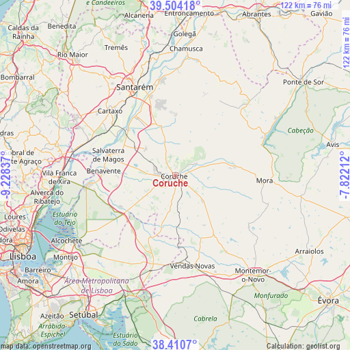
Coruche GPS coordinates[2]
38° 57' 34.38" North, 8° 31' 30.864" West
| Map corner | latitude | longitude |
|---|---|---|
| Upper-left | 39.50418°, | -9.22837° |
| Center: | 38.95955°, | -8.52524° |
| Lower-right: | 38.4107°, | -7.82212° |
| Map W x H: | 121.6×121.6 km | = 75.6×75.6mi |
| max Lat: | 42.11337° ⇑65% North |
| Coruche: | 38.95955° |
| min Lat: | ⇓35% South 32.6448° |
| min Long | Coruche | max Long |
| -31.17847° | -8.52524° | -6.27308° |
| W 53.1%⇐ | ⇒46.9% E |
Elevation
Elevation of Coruche is 21 m = 69 ft, and this is 156 m = 512 ft below average elevation for this country.
| Max E: |
1008 m = 3307 ft | 86.8% |
| Avg. | 177 m = 581 ft | |
| Coruche | 21 m = 69 ft | |
Min E: |
-128 m = -420 ft | 13.2% |
See also: Portugal elevation on elevation.city.
Geographical zone
Coruche is located in North temperate zone (between Tropic of Cancer and the Arctic Circle). Distance of this Northern Tropic circle is 1726 km =1072.5 mi to South.| Distance of | km | miles | from Coruche |
|---|---|---|---|
| North Pole | 5675.2 | 3526.4 | to North |
| Arctic Circle | 3069.3 | 1907.2 | to North |
| Tropic Cancer | 1726 | 1072.5 | to South |
| Equator | 4331.9 | 2691.7 | to South |


Nearby cities:
15 places around Coruche: (largest is in red/bold)
• Almeirim
29 km =18 mi,  342°
342°
• Azambuja
32.1 km =19.9 mi,  292°
292°
• Bemfica
24.8 km =15.4 mi,  325°
325°
• Benavente
24.5 km =15.2 mi,  275°
275°
• Cartaxo
31.8 km =19.8 mi,  314°
314°
• Fazendas de Almeirim
24.3 km =15.1 mi,  351°
351°
• Marinhais
18.1 km =11.2 mi,  302°
302°
• Mora
31.3 km =19.4 mi,  93°
93°
• Poceirão
27.3 km =17 mi,  238°
238°
• Salvaterra de Magos
24.4 km =15.2 mi, 288°
• Samora Correia
30.1 km =18.7 mi,  265°
265°
• Santo André
26.5 km =16.5 mi,  66°
66°
• Vale de Santarém
31 km =19.3 mi, 325°
• Vendas Novas
31.9 km =19.8 mi,  169°
169°
• Vila Chã de Ourique
31.5 km =19.6 mi,  318°
318°
Sources, notices
• [Note1] Compared only with cities in Portugal existing in our database
• [Src1] Map data: © OpenStreetMap contributors (CC-BY-SA)
• [Src2] Other city data from geonames.org with taken over terms of usage.
• [Src3] Geographical zone / Annual Mean Temperature by Robert A. Rohde @ Wikipedia
