Mora geodata
Mora (Évora) is a seat of a second-order administrative division; located in Portugal in Europe/Lisbon (GMT+1) time zone. In our database, there are 824 cities with bigger population. Compared to other cities in Portugal, 65.5% of cities are located further ↑North; 74.7% of cities are located further ←West and 50% of cities have lower elevation than Mora. Note1


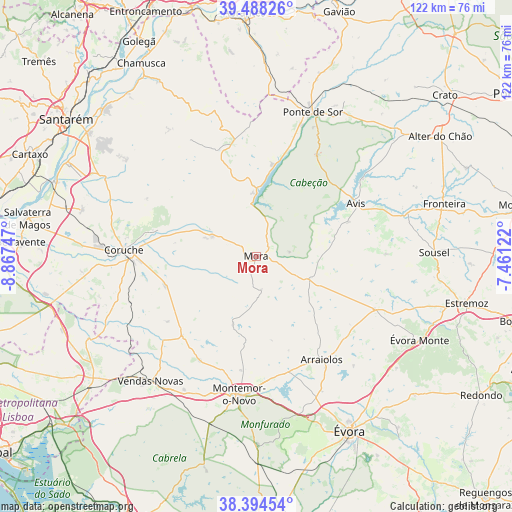
Mora GPS coordinates[2]
38° 56' 36.636" North, 8° 9' 51.624" West
| Map corner | latitude | longitude |
|---|---|---|
| Upper-left | 39.48826°, | -8.86747° |
| Center: | 38.94351°, | -8.16434° |
| Lower-right: | 38.39454°, | -7.46122° |
| Map W x H: | 121.6×121.6 km | = 75.6×75.6mi |
| max Lat: | 42.11337° ⇑65.5% North |
| Mora: | 38.94351° |
| min Lat: | ⇓34.5% South 32.6448° |
| min Long | Mora | max Long |
| -31.17847° | -8.16434° | -6.27308° |
| W 74.7%⇐ | ⇒25.3% E |
Elevation
Elevation of Mora is 113 m = 371 ft, and this is 64 m = 210 ft below average elevation for this country.
| Max E: |
1008 m = 3307 ft | 50% |
| Avg. | 177 m = 581 ft | |
| Mora | 113 m = 371 ft | |
Min E: |
-128 m = -420 ft | 50% |
See also: Portugal elevation on elevation.city.
Geographical zone
Mora is located in North temperate zone (between Tropic of Cancer and the Arctic Circle). Distance of this Northern Tropic circle is 1724.2 km =1071.4 mi to South.| Distance of | km | miles | from Mora |
|---|---|---|---|
| North Pole | 5676.9 | 3527.5 | to North |
| Arctic Circle | 3071.1 | 1908.3 | to North |
| Tropic Cancer | 1724.2 | 1071.4 | to South |
| Equator | 4330.1 | 2690.6 | to South |


Nearby cities:
15 places around Mora: (largest is in red/bold)
• Almeirim
49.6 km =30.8 mi,  306°
306°
• Alpiarça
50.1 km =31.1 mi, 314°
• Arraiolos
29 km =18 mi,  147°
147°
• Avis
26.6 km =16.5 mi,  62°
62°
• Coruche
31.3 km =19.4 mi,  273°
273°
• Fazendas de Almeirim
43.4 km =27 mi, 306°
• Fronteira
46.3 km =28.8 mi,  74°
74°
• Marinhais
47.9 km =29.8 mi,  283°
283°
• Montargil
14.9 km =9.3 mi,  357°
357°
• Montemor-o-Novo
33.1 km =20.6 mi,  187°
187°
• Ponte de Sôr
36.5 km =22.7 mi,  21°
21°
• Santo André
14.2 km =8.8 mi,  330°
330°
• Vale da Amoreira
42.6 km =26.5 mi, 70°
• Vendas Novas
39 km =24.2 mi,  220°
220°
• Évora
47.8 km =29.7 mi, 151°
Sources, notices
• [Note1] Compared only with cities in Portugal existing in our database
• [Src1] Map data: © OpenStreetMap contributors (CC-BY-SA)
• [Src2] Other city data from geonames.org with taken over terms of usage.
• [Src3] Geographical zone / Annual Mean Temperature by Robert A. Rohde @ Wikipedia
