Vendas Novas geodata
Vendas Novas (Évora) is a seat of a second-order administrative division; located in Portugal in Europe/Lisbon (GMT+1) time zone. With population of 11,248 people, there are 188 cities with bigger population in this country. Compared to other cities in Portugal, 75.9% of cities are located further ↑North; 58% of cities are located further ←West and 58.7% of cities have lower elevation than Vendas Novas. Note1


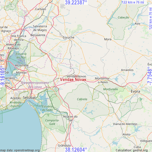
Vendas Novas GPS coordinates[2]
38° 40' 37.416" North, 8° 27' 28.512" West
| Map corner | latitude | longitude |
|---|---|---|
| Upper-left | 39.22387°, | -9.16105° |
| Center: | 38.67706°, | -8.45792° |
| Lower-right: | 38.12604°, | -7.7548° |
| Map W x H: | 122.1×122.1 km | = 75.9×75.9mi |
| max Lat: | 42.11337° ⇑75.9% North |
| Vendas Novas: | 38.67706° |
| min Lat: | ⇓24.1% South 32.6448° |
| min Long | Vendas Novas | max Long |
| -31.17847° | -8.45792° | -6.27308° |
| W 58%⇐ | ⇒42% E |
Elevation
Elevation of Vendas Novas is 148 m = 486 ft, and this is 29 m = 95 ft below average elevation for this country.
| Max E: |
1008 m = 3307 ft | 41.3% |
| Avg. | 177 m = 581 ft | |
| Vendas Novas | 148 m = 486 ft | |
Min E: |
-128 m = -420 ft | 58.7% |
See also: Portugal elevation on elevation.city.
Geographical zone
Vendas Novas is located in North temperate zone (between Tropic of Cancer and the Arctic Circle). Distance of this Northern Tropic circle is 1694.6 km =1053 mi to South.| Distance of | km | miles | from Vendas Novas |
|---|---|---|---|
| North Pole | 5706.6 | 3545.9 | to North |
| Arctic Circle | 3100.7 | 1926.7 | to North |
| Tropic Cancer | 1694.6 | 1053 | to South |
| Equator | 4300.5 | 2672.2 | to South |


Nearby cities:
15 places around Vendas Novas: (largest is in red/bold)
• Alcochete
44.5 km =27.7 mi,  281°
281°
• Alcácer do Sal
34.1 km =21.2 mi,  188°
188°
• Arraiolos
41.4 km =25.7 mi,  82°
82°
• Benavente
45.2 km =28.1 mi,  317°
317°
• Comporta
43.6 km =27.1 mi,  220°
220°
• Coruche
31.9 km =19.8 mi,  349°
349°
• Montemor-o-Novo
21.4 km =13.3 mi,  98°
98°
• Montijo
44.9 km =27.9 mi,  274°
274°
• Mora
39 km =24.2 mi,  40°
40°
• Palmela
40.3 km =25 mi,  252°
252°
• Pinhal Novo
39.9 km =24.8 mi,  262°
262°
• Poceirão
33.8 km =21 mi,  300°
300°
• Quinta do Anjo
43.8 km =27.2 mi, 253°
• Sarilhos Pequenos
45.5 km =28.3 mi, 270°
• Setúbal
41.1 km =25.5 mi, 245°
Sources, notices
• [Note1] Compared only with cities in Portugal existing in our database
• [Src1] Map data: © OpenStreetMap contributors (CC-BY-SA)
• [Src2] Other city data from geonames.org with taken over terms of usage.
• [Src3] Geographical zone / Annual Mean Temperature by Robert A. Rohde @ Wikipedia
