Grândola geodata
Grândola (District of Setúbal) is a seat of a second-order administrative division; located in Portugal in Europe/Lisbon (GMT+1) time zone. With population of 10,737 people, there are 203 cities with bigger population in this country. Compared to other cities in Portugal, 82.5% of cities are located further ↑North; 50.2% of cities are located further →East and 52.5% of cities have higher elevation than Grândola. Note1


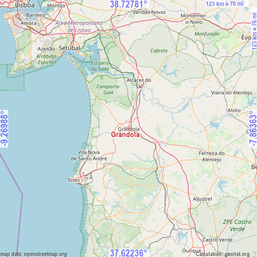
Grândola GPS coordinates[2]
38° 10' 37.848" North, 8° 34' 0.3" West
| Map corner | latitude | longitude |
|---|---|---|
| Upper-left | 38.72781°, | -9.26988° |
| Center: | 38.17718°, | -8.56675° |
| Lower-right: | 37.62236°, | -7.86363° |
| Map W x H: | 122.9×122.9 km | = 76.4×76.4mi |
| max Lat: | 42.11337° ⇑82.5% North |
| Grândola: | 38.17718° |
| min Lat: | ⇓17.5% South 32.6448° |
| min Long | Grândola | max Long |
| -31.17847° | -8.56675° | -6.27308° |
| W 49.8%⇐ | ⇒50.2% E |
Elevation
Elevation of Grândola is 102 m = 335 ft, and this is 75 m = 246 ft below average elevation for this country.
| Max E: |
1008 m = 3307 ft | 52.5% |
| Avg. | 177 m = 581 ft | |
| Grândola | 102 m = 335 ft | |
Min E: |
-128 m = -420 ft | 47.5% |
See also: Portugal elevation on elevation.city.
Geographical zone
Grândola is located in North temperate zone (between Tropic of Cancer and the Arctic Circle). Distance of this Northern Tropic circle is 1639 km =1018.4 mi to South.| Distance of | km | miles | from Grândola |
|---|---|---|---|
| North Pole | 5762.2 | 3580.5 | to North |
| Arctic Circle | 3156.3 | 1961.2 | to North |
| Tropic Cancer | 1639 | 1018.4 | to South |
| Equator | 4244.9 | 2637.7 | to South |


Nearby cities:
15 places around Grândola: (largest is in red/bold)
• Alcácer do Sal
22.3 km =13.9 mi,  11°
11°
• Aljustrel
48.4 km =30.1 mi,  133°
133°
• Alvito
51 km =31.7 mi,  80°
80°
• Cercal
42.8 km =26.6 mi,  192°
192°
• Comporta
29.6 km =18.4 mi,  319°
319°
• Ferreira do Alentejo
48.8 km =30.3 mi,  106°
106°
• Mombeja
49.3 km =30.6 mi, 110°
• Palmela
52.4 km =32.6 mi,  326°
326°
• Porto Covo
41.1 km =25.5 mi,  208°
208°
• Santiago do Cacém
21 km =13 mi, 212°
• Santo André
22.9 km =14.2 mi,  235°
235°
• Setúbal
47.7 km =29.6 mi, 324°
• Sines
36.2 km =22.5 mi,  227°
227°
• São Luis
52 km =32.3 mi, 189°
• Viana do Alentejo
52.1 km =32.4 mi,  70°
70°
Sources, notices
• [Note1] Compared only with cities in Portugal existing in our database
• [Src1] Map data: © OpenStreetMap contributors (CC-BY-SA)
• [Src2] Other city data from geonames.org with taken over terms of usage.
• [Src3] Geographical zone / Annual Mean Temperature by Robert A. Rohde @ Wikipedia
